

Why so few people live in southern Oregon and northern California
Also known as the lost state of Jefferson
Welcome to the first edition of “Why Wednesday” the article series where I’ll be answering great big geographic why questions. As I fine tune our content release schedule here on The Bight, I’m starting to better understand what people want and a big one that has risen time and again is that people want answers. I’m here to help deliver some of those answers… with a geographic twist of course!
And for those of you worried about paywalls, don’t be. Why Wednesdays will remain free for all.
Okay, to kick us off, I want to revisit an area that has always fascinated me: southern Oregon and northern California. A region that some might better know as the state of Jefferson, but is otherwise a very different region that the rest of the west coast. Long time fans of mine might remember that I made a video about this over on my YouTube channel but it’s been a few years and I think it’s time we revisit the region. A little bit of an update, if you will. But first, before we do that, let’s dive into where specifically we’re talking about.
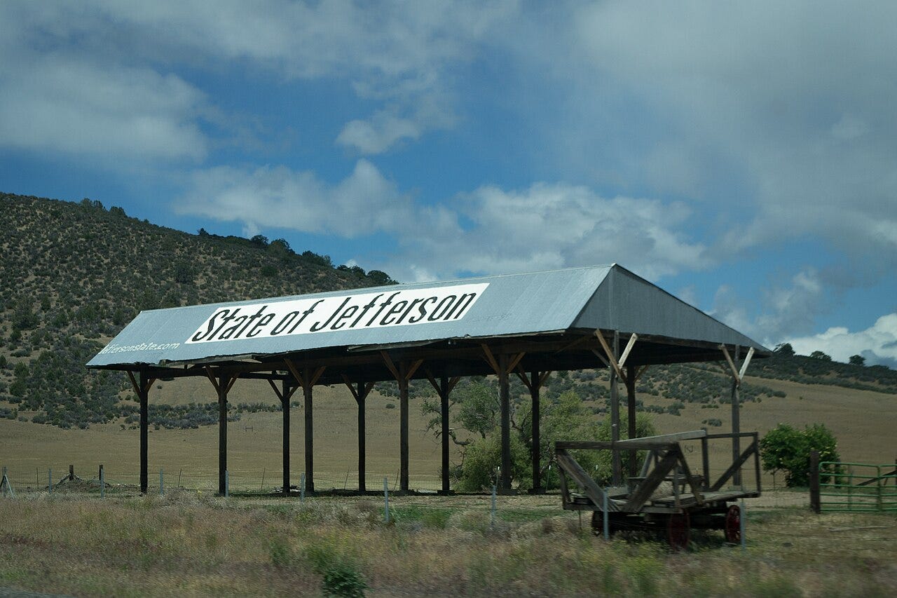
The state of Jefferson
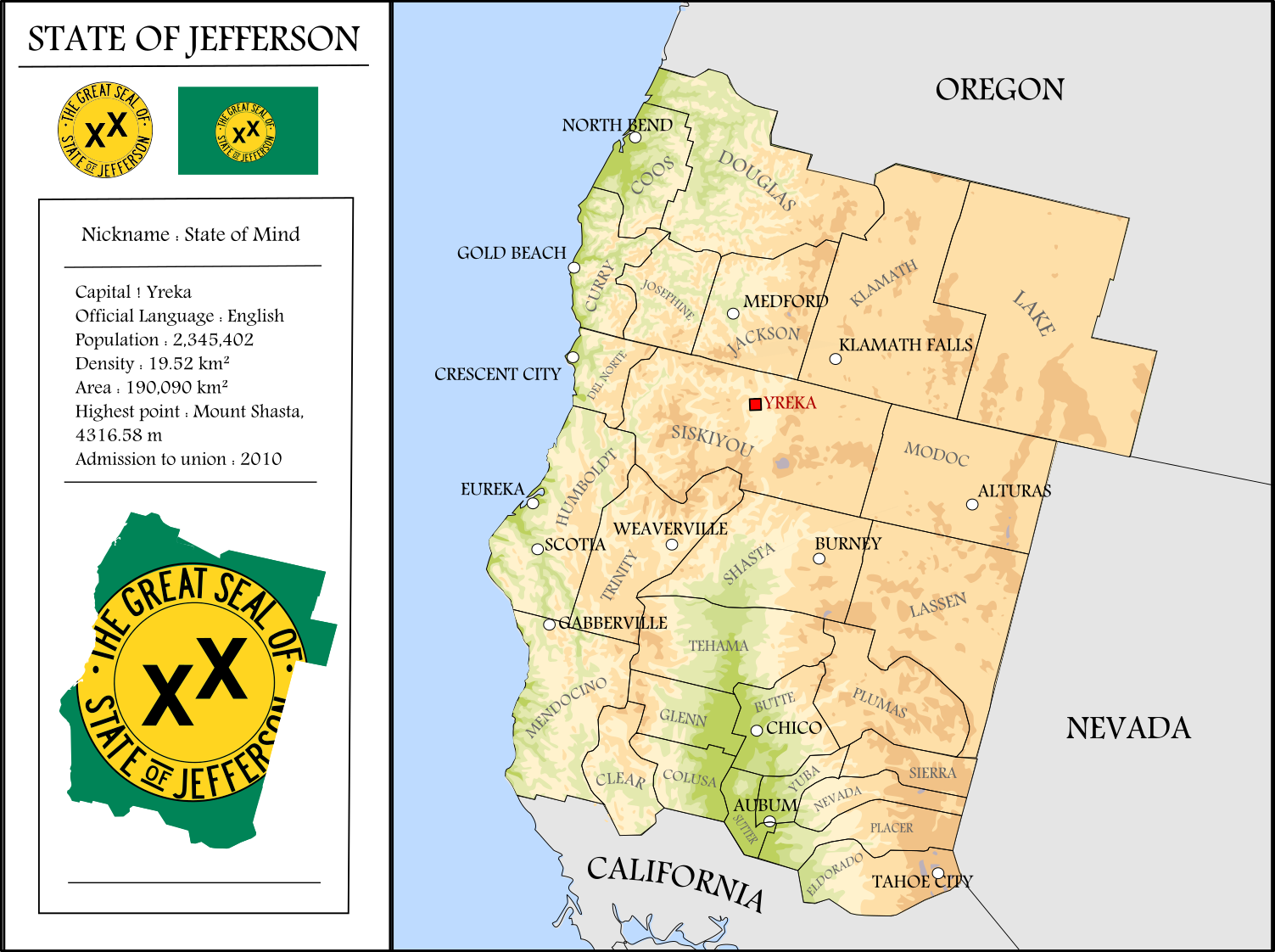
Okay, so basically, this article is about a thing that almost came into existence called the state of Jefferson. Which, if you’re unfamiliar, was a movement that attempted to secede from both Oregon and California to form a brand new state (called Jefferson, obviously) in the early-ish 1900s. The plan actually gained quite a bit of momentum… right up until World War II happened and basically everything stalled out. When the war was over, there was little appetite in the country for any kind of division.
But essentially, in the modern context, this would be from just south of the Willamette Valley, just south of where Eugene, Oregon is, all the way to just north of where Sacramento, California is. And while there are people living here (over 2 million!) it does make for an interesting region given the relative population density north and south of it. In fact, you can see this on a modern day light pollution map:
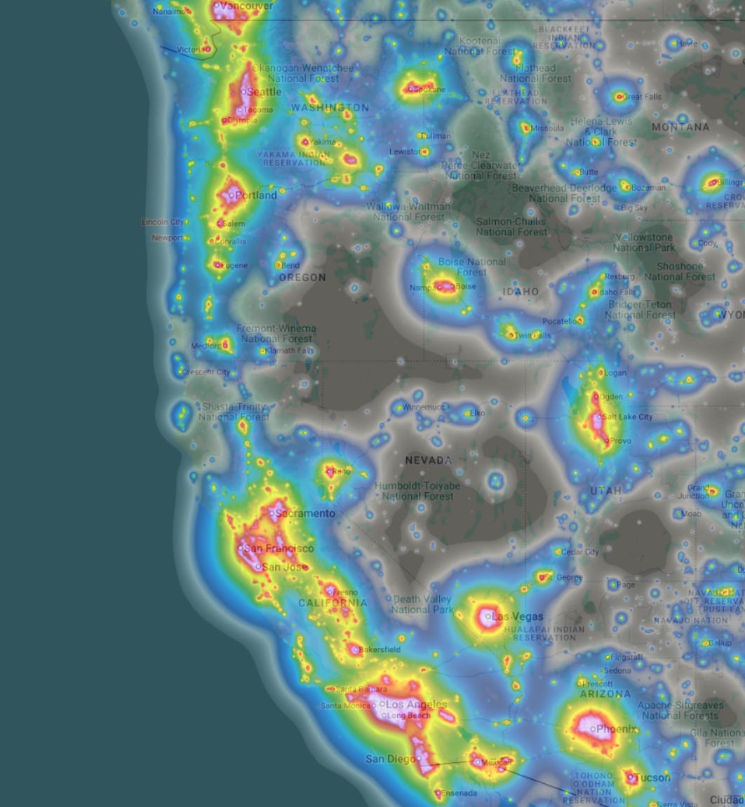
Light, after all, can tell you pretty quickly where people are and where they aren’t. And while there are some light bubbles around Medford, Oregon, and Redding, California, they’re quite minuscule comparatively. So what’s going on?
Driving through here is a nightmare

Well let’s start with the obvious topographic elephant in the room. When people think of West Coast mountains, they’re usually picturing places like the volcanic peaks of the Cascades or the large and imposing Sierra Nevadas or, to a lesser extent, the coastal ranges. All of which generally run in a north-south direction. However, the region between Eugene and Sacramento is dominated by a completely different and far more chaotic system: the Klamath-Siskiyou Mountains.
Unlike these, which generally have flat valleys alongside or in between them, the Klamath and Siskiyou ranges are more like a jumbled maze of ridges and canyons moving in every direction. This geological confusion creates an immediate problem for civilization:
First, building roads, bridges, and railways through non-linear mountain ranges is astronomically expensive. For decades, the area was virtually inaccessible except by perilous dirt tracks. Even today, Interstate 5 is forced into tight, steep curves and dramatic elevation changes through the Siskiyou Summit (4,310 feet). Which also means that the West Coast’s primary artery transportation can get shut down due to blizzard like conditions.
But also, because the terrain is so rugged, driving from an inland town like Ashland or Medford to the coast can take three hours or more, even though the ocean is less than 70 miles away in a straight line.
Fundamentally, this region’s topography is COMPLETELY different from the rest of the West Coast all the way up to Canada and then all the way down to Mexico. In fact, the nearest place you’d get something similar, in my opinion, is in British Columbia just north of Vancouver where, you guessed it, there also aren’t a whole lot of people.
Which leads us to the next big reason.
No natural harbors

Most major coastal cities around the world require a deep-water natural harbor to establish trade and fuel early economic growth. Seattle has the Puget Sound, San Francisco has its massive bay, and Portland sits on the navigable Columbia River and so on and so forth.
This region has none of these. Not really anyways. There is one tiny exception here, but we’ll get to that in a minute.
Instead, the coastline between northern California and southern Oregon is essentially just sheer cliffs dropping directly into the Pacific Ocean, most famously epitomized by California’s Lost Coast, a region so rugged that engineers building State Route 1 were forced to divert the highway entirely inland because they just couldn’t build there. It’s a beautiful area though and you should definitely check it out.
And the few bays that do exist, such as Humboldt Bay (home to Eureka) or Coos Bay (home to… ahem Coos Bay) farther north, both suffer from fatal flaws such as shallow waters that need to be constantly dredged as well as a lack of deep navigable rivers like the Columbia connecting them to places like Medford or Redding. Basically, they’re both pretty useless for major freight shipping and logistics.
But let’s say you didn’t need a large port, and you were willing to invest in all of the infrastructure. There’s still one other problem at the heart of all this…
There’s just not enough physical space
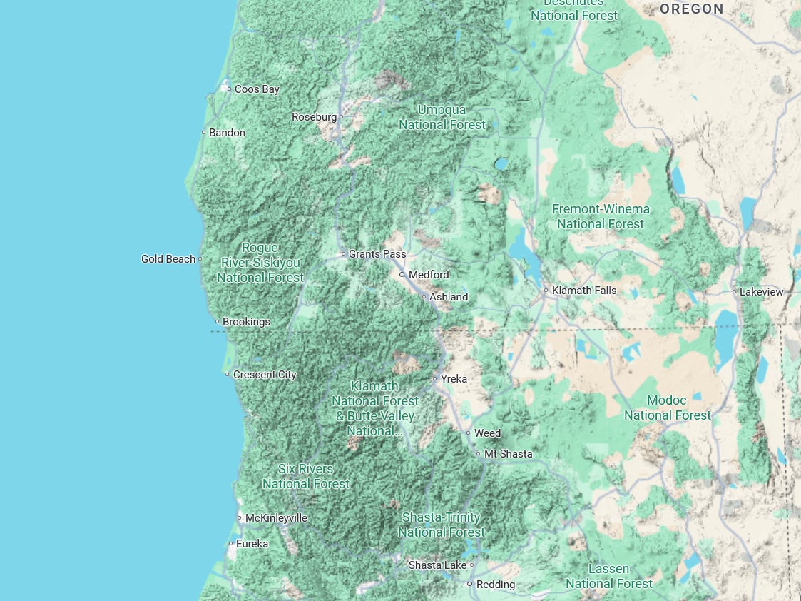
This ties back into the infrastructure and topography a bit, but the reality is that metropolitan areas take a lot of space. At least here in the United States where we basically sprawl out endlessly. And if you look at the above map, you’re going to notice that there’s really just not that much space for a major city. A metro region the size of Portland, Oregon, which is basically the smallest on the West Coast, wouldn’t fit anywhere in that mess of mountains.
And this isn’t even considering the federal land ownership at play. Between the Rogue River-Siskiyou, Klamath, Shasta-Trinity, and Six Rivers National Forests, the Bureau of Land Management, and various other national parks and monuments, account for roughly 60% to 80% of the land in these counties is public. Just to give some examples:
Trinity County, CA ~90%
Siskiyou County, CA ~60%
Douglas County, OR ~50%
Even if you had a gajillion dollars to put a city here, because this land is federally protected, it can’t be used for suburban housing tracts, industrial parks, or massive commercial centers. At least not without a major intervention by Congress which… ain’t happening. This means that the population of the region is permanently funneled into a few narrow valley floors, like the Rogue Valley (Medford) and the northern tip of the Central Valley (Redding).
This isn’t gonna change

There’s a reason why people live where they do. Why cities pop up where they do. Why we have a concentration of people and industry in specific places. It’s because there was a pull factor. Something that drew in people who then stayed and began creating new things which then pulled in more people and so on and so forth.
During the early years of settlement and colonization, these pull factors were often natural resource based. A mountain made of silver or gold. A large open valley with great soil for growing food. An incredibly deep and sheltered body of water for trade and fishing. This region all had little bits of these things, but nothing ever in a mass enough quantity to really super charge that early migration pattern. And today, after all major cities have been founded and established, there’s likely not going to be anything that really draws people here.
That’s not a bad thing, though! Personally, I think this region benefits quite a bit from a lack of major population centers. And while they certainly would have preferred more political representation in the early 1900s, had they succeeded, there’s a strong likelihood that the state of Jefferson would look radically different that the region does today.
Final thought: if you ever decide to visit, skip the I-5 journey, head up or down highway 101. It is, easily, one of the best road trips I’ve ever experienced. The sheer amount of places to stop over and just absorb the view is staggering. And don’t forget to head inland a bit too! A personal favorite place of mine is Golden and Silver Falls State Natural Area just a bit east from Coos Bay. It’s remarkable and almost nobody visits.
Have you ever visited this region? What do you think? Let me know in the comments!
In 1977 my friend and I rode our motorcycles up and down the West Coast - I have very strong memories of the "State of Jefferson" - we visited an "ice cave" in N. California which was basically a small frozen puddle at the bottom of a long series of steps. Crater Lake is worth a journey. The monstrous slugs living in the cool, damp coastal forests were a little scary! We also camped on a gravel river bed of the Rogue River which was fun and a great place to camp but in hindsight was stupidly dangerous!
I really like this area because of it's lesser population. I lived in Oregon for a bit (Newport and then Corvallis for college) and used to travel down through that area to get to Reno. I also obtained my private pilot's license while in college and loved flying over the area and into Medford.