

Why the United States has this odd checkerboard pattern
The pattern is most often found in western states, but exists sporadically throughout the country.
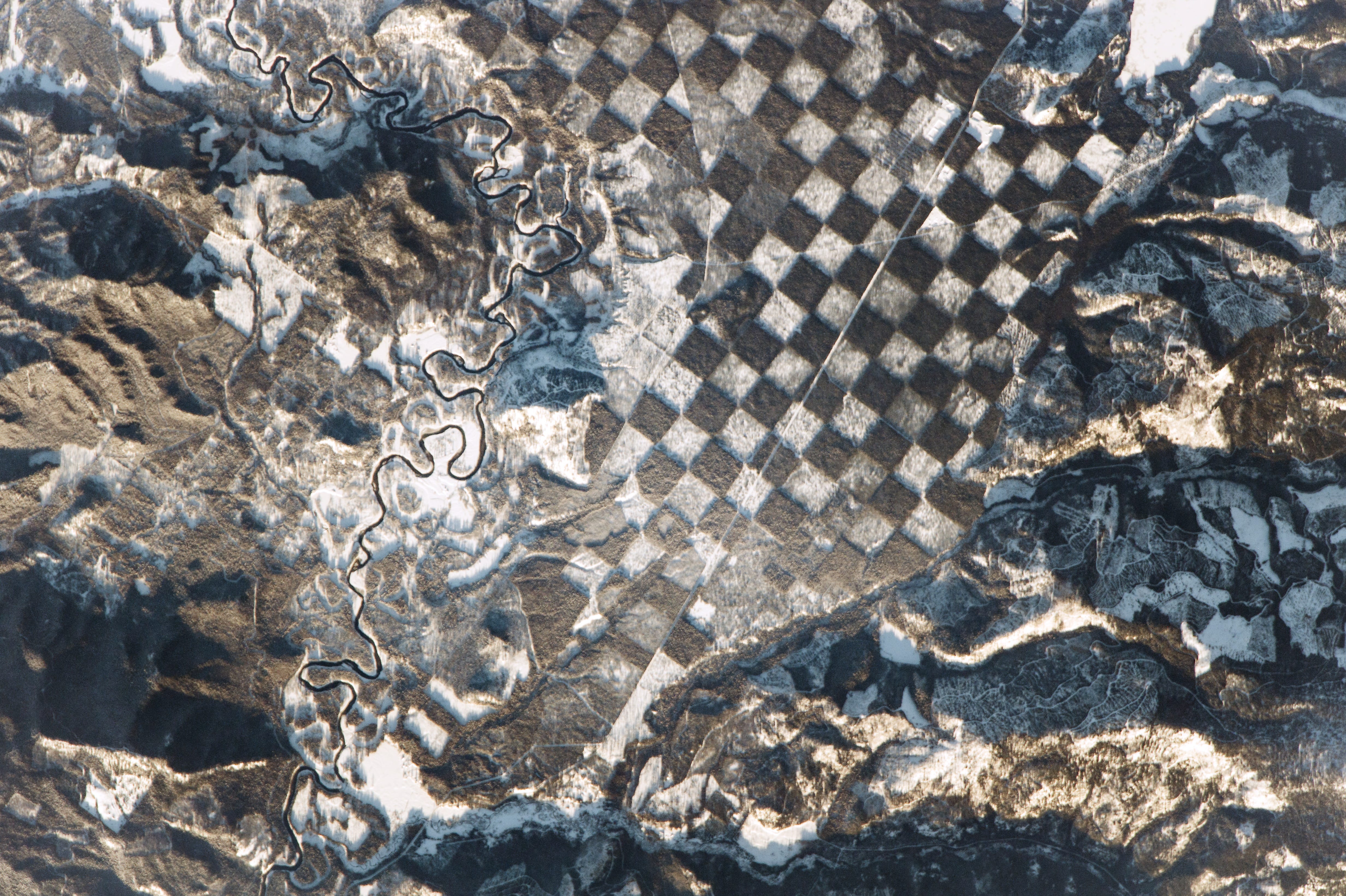
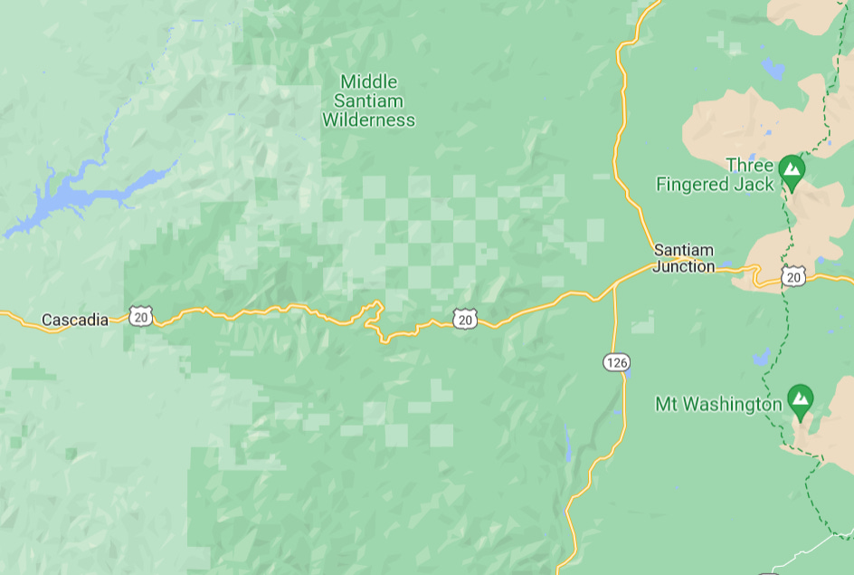
Have you ever been scrolling around Google Maps (or Apple Maps) and come across an odd pattern you couldn’t quite make sense of? It probably looked a little bit like a checkerboard except instead of black and white they are associated with whatever land use exists nearby. In most cases, the areas are green and lighter green which means they’re likely forested in some capacity. Well, as it turns out, this is not a weird map issue, but an actual method of parceling out land that the United States has used for a long time called “checkerboarding.”
The term checkerboarding refers to a specific pattern of land ownership where parcels of land are interspersed or alternated between two or more owners, much like the squares of a checkerboard. It's a phenomenon that characterizes significant parts of the United States, particularly the West, and complicated history associated with it. While sometimes there were very legitimate reasons to checkerboard land, other times it was used for more nefarious reasons.
Origins of checkerboarding
As with most things in the the historic western states, checkerboarding originated in the 1800s as a byproduct of U.S. giving land to rail companies. The Federal Government granted every other square mile of land (each being around 640 acres) on either side of the railway tracks to the railroad companies, such as the Union Pacific and Central Pacific, while retaining ownership of the alternate sections. Odd-numbered plots were given to private railroad companies, and the federal government kept even-numbered plots.
This policy was designed to stimulate the construction of railroads across the vast distances of the American West with the logic being that railroad companies, who now owned vast quantities of land, would help improve the land and thus increase its value. The Federal Government would own roughly half the land that was being improved (due to the checkerboard nature) and therefore would also reap the benefits of this private investment.
Unfortunately, it didn’t quite work out this well. While railroads were built, it turns out that most of the land never really increased in value. Most people moving to the west were not that wealthy and couldn’t afford to purchase land from the Federal Government. Eventually, through various homesteading acts, much of this land would be given away.
Fracturing Native American lands
But while the development of railroads and land in the west was certainly a priority for the Federal Government. Another reason it was done was to break up Native American lands throughout the west. Enter the Dawes Act of 1887.
The Dawes Act, also known as the General Allotment Act, was signed into law in 1887 by President Grover Cleveland. Its goal was to assimilate Native American tribes into American society by breaking up tribal communal lands into individual allotments. Native American families were given plots of land, typically 160 acres, with the intent that they would become individual farmers. Remaining lands were often sold to non-Native settlers.
As a consequence, the Dawes Act significantly fractured land that Native Americans held communally prior. Prior to the act passing, tribal lands were not individually owned, but the allotment policy split these tribal lands into areas where a single family would be expected to farm or manage it — a very western way of thinking. The resulting pattern of ownership frequently resembled a checkerboard, with alternating squares of Native and non-Native land.
Unfortunately, this policy had numerous negative consequences. Most indigenous people and tribes were not familiar with the concept of individual land ownership and lacked the resources or knowledge to succeed in farming, leading to poverty and displacement. Furthermore, large tracts of tribal lands were lost through the sale of 'surplus' lands. It's estimated that Native American tribes lost about two-thirds of their landholdings between 1887 and 1934, when the policy was reversed with the Indian Reorganization Act.
In this way, the Dawes Act created a checkerboarding effect that disrupted Native American communities, accelerated the loss of tribal lands, and resulted in complicated patterns of land ownership that persist to this day, causing ongoing disputes and challenges in land management. Essentially: it’s a mess out there!
Additional reasons for checkerboarding
While railroads and Native American land parceling are two of the most obvious reasons for checkerboarding the land, there are a few other reasons why its done as well.
Facilitate access to resources
Checkerboarding is a way for the government to maintain access to vital resources. By alternating ownership, the government can ensure it retains control over sections of land that could potentially be rich in resources like timber, minerals, or water sources.
This is something we see most often with timber lands in national forests. The federal government will retain roughly half of large tracts of forested lands where it will ensure that the entire forest isn’t clear cut and they can maintain good forestry practices.
Land management and conservation efforts
But also, in the modern era, checkerboarding poses unique challenges and opportunities for land management and conservation. In some cases, public and private entities collaborate to manage resources and protect ecosystems that span across the checkerboard ownership lines. In other cases, land swaps or purchases are arranged to consolidate ownership and simplify management. Basically, it can give the Federal Government a useful tool in negotiations with private entities if it needs to refocus its efforts on conservation or rehabilitation.
Consequences of checkerboarding

While checkerboarding was a useful strategy for promoting development and resource access at one time, today it has led to many or more challenges. Basically, it super complicates land and resource management because neighboring parcels may be subject to different regulations depending on whether they are privately owned or federally managed. This can lead to fragmented habitats, posing challenges to things like wildlife conservation. Imagine, if you will, that every other block in your neighborhood was part of a different city. You would never be able to get all the rules and regulations in order to do much of anything. That’s kind of what checkerboarding has done to wild lands today.
In recent years, efforts have been made to address these challenges. Land swaps, where owners trade parcels to consolidate their holdings, have become a common solution. Conservation groups also sometimes purchase lands to protect sensitive ecosystems. While these strategies can be effective, they also require complex negotiations and planning, and in some cases may be controversial.
To sum it all up: the U.S. system of managing lands is wild!