

Why the mighty "Mississippi" and not the mighty "Missouri" River
There's an argument that the Mississippi River should be the Missouri River

Oh place names. We love a place name here at The Bight. In fact, I’d argue that everyone loves a place name even if they don’t recognize that they do. When we name a place, we create an identity around it, a feeling associated with it, and, because of that, we grow attached to that name as being of that identity and feeling. It’s why renaming things can be so contentious. Even relatively small renamings can face fierce opposition. Point in case: about a decade ago, my home city of Portland, Oregon decided to rename a street named 39th to Cesar Chavez Blvd (recent controversy aside, this was well before that) and people were UP. IN. ARMS.
So, needless to say, larger renamings can bring about even more opposition. Hello Gulf of Mexico/America and Denali/Mt McKinley. But I digress. This post isn’t about renaming things necessarily. It’s just the beginnings of a rather large caveat I want to include before we dive into the meat of this article. Which is to say:
I am not proposing we change the name of the lower half of the Mississippi River to the Missouri River. I’ll say that again (louder):
I am not proposing we change the name of the lower half of the Mississippi River to the Missouri River.
This is merely a geographic exploration of the two largest rivers in the Mississippi River watershed and how, had we explored things a bit differently, it’s very likely the Missouri River would have been the primary river within it, all the way down to the Gulf of Mexico, and the Mississippi River ending at the confluence in present day St. Louis-ish.
And really it’s an exploration of how we even determine the head waters of a river more broadly. Because, in the end, these things are all connected. That’s kind of the whole point.
The starting point of a river
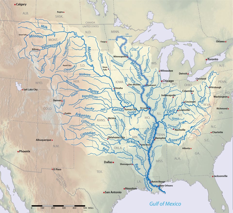
Okay so, if you trace a river upstream from a sea, ocean, etc. on a map, you’ll eventually hit a fork. So how do geographers, cartographers, and explorers decide which branch is the “main” river and which is just a tributary? Well, as it turns out, finding a river’s true headwaters isn’t an exact science, it’s usually a messy combination of three different metrics:
According to what I can find, the most common modern method is to follow the longest continuous stream of water all the way back to its original source. If you measure from the mouth of the river to the furthest possible drop of water that flows into it, that point is technically the hydrologic headwaters.
But sometimes, length doesn’t tell the whole story. When two rivers meet, hydrologists can often look at which one is carrying more water. The branch with the larger discharge is frequently crowned the main stem, regardless of how far back it stretches.
But, ultimately, I’d say that history is usually the greatest determining factor. Geography, after all, is a human endeavor, which means it’s prone to historic quirks. Early explorers mapped rivers from the mouth upstream, often naming the main stem based on the widest channel, the clearest water, or simply the direction they happened to be traveling. Once a name was inked on a map, it usually stuck even if later surveys proved a different branch was longer.
This brings us to one of the greatest geographic naming quirks in North America: the Mississippi and Missouri River divide.
The Missouri River Watershed?
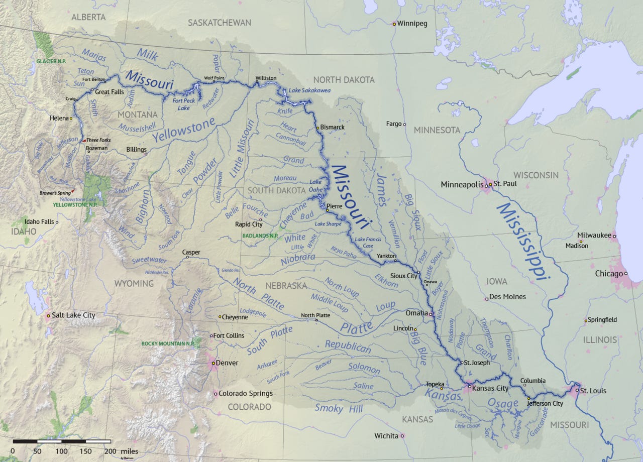
If we play by the “longest channel” rule, the primary river of the North American continent would undoubtedly be the Missouri River, not the Mississippi River.
The Missouri River, as it exists today, stretches roughly 2,341 miles from its headwaters in the Rocky Mountains of Montana down to its confluence with the Mississippi River near St. Louis. From that intersection, the water travels another 1,150 miles down to the Gulf of Mexico. If you combine them into a single system, the Missouri-Mississippi river is the fourth longest in the world.
By contrast, the Mississippi River today, from its headwaters at Lake Itasca in northern Minnesota all the way to the Gulf of Mexico, travels only 2,340 miles, a single mile SHORTER than the cut-off Missouri River.
So why does the Mississippi get the naming rights all the way to the Gulf?
It ultimately comes down to a mix of volume and history (shocking right?)
Basically, when the Missouri and the Upper Mississippi meet in St. Louis, the Missouri is significantly longer, but the Mississippi is wider and carries slightly more water. To early mapmakers, the Mississippi looked like the main stem, while the muddy Missouri looked like a large tributary flowing into it.
And if we played strictly by the volume rule, the Ohio River would actually be the main stem, as it carries vastly more water than the Mississippi where they meet in Cairo, Illinois! Which just so happens to be the subject of today’s Geography By Geoff video, available on YouTube OR ad and sponsor free right here if you’re a paid subscriber:
But mostly it’s named the Mississippi because European explorers moving down from the Great Lakes (like Jacques Marquette and Louis Jolliet) encountered and named the Upper Mississippi long before the full, winding length of the Missouri River was ever mapped by the Lewis and Clark expedition.
By the time geographers realized the Missouri River was significantly longer than the Upper Mississippi, the maps were already printed, the borders were drawn, and the history was settled. The longest river in North America was officially relegated to tributary status.
Ultimately, it doesn’t really mean all that much. But it is a fascinating geographic inconsistency, if you will.
Nice stuff on the rivers! Now to go build me a raft ready for floatin'...haha
I did not know these facts about the Missouri River. I have a lot more respect for it now.