

Why The Gambia has a long, narrow border that straddles a single river
Most country borders are defined by rivers, but few are as unique as The Gambia's
A country’s or state’s border is often defined by a river. Not always, but it’s common enough that I can ramble off a few different country borders that use one:
The United States - Mexico border on the Rio Grande
The Russia - Chine border on the Amur River
The Argentina - Paraguay border on the Pilcomayo River
And so on and so on. But while a river often defines a border, there is only one country who uses the river as its geographic center with a border that entirely surrounds said river and that country is: The Gambia!
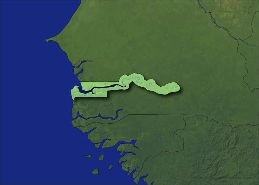
The Gambia’s borders are very interesting. As Africa's smallest mainland country, it is completely surrounded by Senegal, except for a small Atlantic coastline. And right in the middle is the Gambia River. If you look at it on Google Maps, you’ll almost think that some cartogapher just extended a few mile buffer around the river and called it a day. And if you did think that, well you’d mostly be right!
Regardless, The Gambia’s unusual shape and location can be traced back to European colonizers, probably to the surprise of absolutely no one.
History of colonization by Europeans
Colonization is something that every continent has dealt with to some degree. In the Americas, of course, we have a pretty brutal history of colonization leading to the extermination of native populations. In Asia, colonization was highly exploitative of resources and goods (such as the British using India to mass grow and export tea for local consumption). And, of course has its own very ugly history with colonization. And its because of these colonial efforts that we get many of the African borders that exist today.
The Portuguese would be the first European colonizers to really start to explore the west coast of Africa around the late 1400s. During this time the Portuguese crown would send multiple explorations to the region we know today as Senegal and The Gambia. It was during one of these missions that they discovered the Gambia River. Initially, the Portuguese took interest in the region due to its potential as a route for trade, particularly for gold, ivory, and, of course, slaves.
The Portuguese would largely rule of the area for the next century, but by the late 1500s century, they had leased trading rights along the Gambia River to English merchants, marking the beginning of British influence in the region.
During the 1700s and 1800s an intense scramble for African territories by European powers, mainly Britain and France, would kick off. And the two countries' respective spheres of influence would overlap in several regions, leading to conflicting claims. This tussle played out in the Senegambia region, encompassing modern-day Senegal and The Gambia. But while both powers had established trading posts along the Gambia River, the British maintained control over the river's mouth. This strategic position turned out to be a decisive factor in the border formation that was to come.
The Peace of Paris of 1783
While both nations' claims were intermixed, they agreed to define their spheres of influence for the sake of commerce and avoiding conflict. The turning point in shaping The Gambia's borders came with the Peace of Paris series of treaties in 1783. Oddly enough, this would also be the same set of treaties that would end the American Revolutionary War and establiush the United States as a country.
The British and the French delineated the borders based on the navigable stretch of the Gambia River. It was agreed that the territory of The Gambia would extend to include the river and its two banks up to a distance from the mouth that a British naval vessel could travel in a day, approximately 10 miles - hence the strange, narrow shape of the country that sticks tightly to the Gambia River.
Post-Colonial era
The Gambia would gain independence from Britain in 1965, and become a fully sovereign nation. However, its borders, as defined by the Paris Treaty, would remain. Over the years, there have been suggestions and proposals to unify The Gambia with Senegal, largely due to their shared cultural and historical ties.
The most notable of these attempts was the Senegambia Confederation, which existed from 1982 to 1989. In 1981, an attempted coup occurred whil The Gambia’s current president was in the United Kingdom. This would lead to Senegalese troops being deployed to The Gambia in order to restore the president to power. Afterwards, the two countries began more formal talks to unify themselves under a single military, currency and economy. However, it was short-lived, and The Gambia has maintained its independence and borders to this day.
It’s worth highlighting here that The Gambia is largely an English speaking country (due to it being a British colony) and Senegal is largely a French speaking country (due to it being a French colony). So any unification would certainly have faced some cultural barriers. That’s not to say that there aren’t local languages, but these are the official and, as such, beaurocratic languages.
And so there you have it! The Gambia has one of the most unique borders of the entire world. It’s really only about 10 miles wide for most of its length and is home to about 2.5 million Gambians. In fact, aside form island countries and microstates, The Gambia might be the only country in the world contained to a single bioregion. Probably worth doing a bit of extra research on that.