

Why Cyprus is the world's most divided island
Yet it's surprisingly peaceful in 2026

The Mediterranean Sea is, geopolitically, already a complicated place. With Europe in the north, Africa in the south, and a bit of Asia (by way of the Middle East) in the east, there are a lot of competing cultures, religions and borders cross-crossing the enter region. But as far as islands go, most things are pretty cut and dry. Not discounting desires for independence, you can pretty easily see who has sovereignty over which island:
Corsica - France
Sardinia - Italy
Crete - Greece
Malta - well, Malta of course
But then there’s Cyprus. Cyprus is complicated because, while there is a country called the Republic of Cyprus, it does not have full sovereignty over the whole island. In fact, it doesn’t even make up half of the islands.
Why Cyprus was divided in the first place
Okay so, the original division of Cyprus is really rooted in decades of ethnic tensions between Greek Cypriots and Turkish Cypriots, which boiled over following its independence from British rule in 1960. The United Kingdom is still very much in the mix today, but we’ll get to them in a bit. For now, let’s return to the Greek and Turkish Cypriots.
Cypriots, in case you were unaware, is the demonym for people of Cyprus.
It all comes back to Greece and Turkey. If you’re not from this part of the world, or haven’t spent much time in it, you might assume Greece and Türkiye are just neighboring countries. And while that kind of closeness is always bound to generate some sort of rivalry and resentment, most neighbors are not quite as hostile towards each other as these two. Aside from the ones in active or cold war (Ukraine/Russia, North/South Korea) the only one I would say is as acrimonious is India and Pakistan.
All of this is to say, because Greece and Türkiye have had such a long and bitter relationship, this has naturally bled over into regions where there are large ethnic populations of both. Cyprus, being near both countries (though physically closer to Türkiye), means it was always bound to be a mini-arena for this rivalry to play out.
But let’s back up and see how this played over over the last few decades:
Independence & unrest (1960-1963)
Cyprus gains independence from Britain. Power-sharing agreements between Greek and Turkish Cypriots quickly break down, leading to violence.
UN Intervention (1964)
The United Nations Peacekeeping Force in Cyprus is established to prevent further fighting, marking the early origins of what would become the “Green Line.”
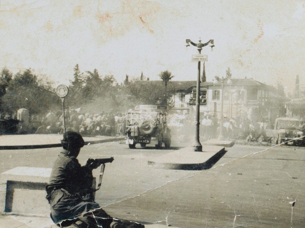
Coup & invasion (1974)
A Greek military junta sponsors a coup in Cyprus aiming to unite the island with Greece (Enosis). In response, Türkiye invades the northern part of the island, citing its role as a guarantor of the 1960 constitution and the need to protect Turkish Cypriots.
The Formal Split (1983)
The Turkish-held north unilaterally declares itself the Turkish Republic of Northern Cyprus, a move condemned by the UN Security Council and recognized only by Türkiye.
The result of the 1974 conflict was a massive population exchange. Hundreds of thousands of people were displaced, with Greek Cypriots fleeing south and Turkish Cypriots moving north. A ceasefire line was established, heavily guarded by UN peacekeepers, effectively slicing the island, and its capital Nicosia, in two.
Whew that was a lot of events in not a lot of words, but we’ve got a whole lot more to cover, starting with who owns what today in 2026.
Cyprus’ borders in 2026
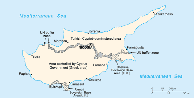
Today, the island is essentially carved into four distinct jurisdictions:
The Republic of Cyprus (The South): This is the internationally recognized government of the island. It controls roughly the southern two-thirds of Cyprus, is predominantly Greek-speaking, and is a member of the European Union. Chances are if you’re flying to Cyprus for a holiday/vacation, this is where you’re going.
The Turkish Republic of Northern Cyprus (aka TNRC, the North): Controlling the northern third of the island, the TRNC operates as a de facto independent state, though Turkey is the only country in the world that recognizes it. It is predominantly Turkish-speaking and relies heavily on Turkey for economic and military support.
The UN Buffer Zone (The Green Line): A demilitarized strip of land running roughly 112 miles (180 km) across the island. In some parts, it is miles wide, containing abandoned villages and farmland; in the heart of Nicosia, it shrinks to just a few yards wide, dividing the city down the middle.
UK Sovereign Base Areas (Akrotiri and Dhekelia): When Britain granted Cyprus independence, it retained two military bases in the south. These remain British Overseas Territories. This last one is probably the least known about Cyprus. According to what I can find online, there are about 20,000 people living in these two regions, making them fairly large territories.
Now, despite the profound political divide, life on both sides of the Green Line continues in a relatively normal way.
The Republic of Cyprus in the south has a fairly robust, service-oriented economy driven by tourism, shipping, and financial services, not unlike Greece today. And just like Greece, it uses the Euro. In 2026, the Republic is making a significant push to join the EU’s border-free Schengen Area. However, this ambition is highly complicated by the Green Line. Since the Republic of Cyprus does not consider the Green Line an “external international border” (as they claim the entire island), implementing Schengen entry/exit systems there is geopolitically challenging, to say the very least.
Meanwhile, the TRNC operates using the Turkish Lira and faces international embargoes, meaning direct flights only arrive from Turkey. Its economy relies heavily on mainland Turkish aid, higher education (hosting numerous universities), and a separate tourism industry that draws largely from Turkey and, increasingly, budget-conscious European travelers willing to brave the much harder path to get in. It’s not illegal, by any means, but if you’re living in Berlin and you see a direct flight to Cyprus, it’s not to this area. You’d have to go to Istanbul first.
All this is to say, if you are wanting to visit, Cyprus is very much open for business. Despite its complexities, it’s a fairly safe region of the world to check out. In fact, as of June 2026, the US State Department dropped its travel advisory for Cyprus down to Level 1 (”Exercise Normal Precautions”), signaling that the main tourist areas are considered very safe. That’s not just for the south or north, but the whole island.
AND you can even cross between the South and North as a tourist if you want. There are nine official checkpoints, the most famous being the pedestrian-only Ledra Street crossing in the heart of Nicosia. To cross, you just need your passport. There is one caveat though: this is only possible if you enter the island from the Republic of Cyprus (the south).
According to what I can find online, you must enter and exit the island through legal ports in the Republic of Cyprus (Larnaca or Paphos airports, or southern seaports). The Republic considers entry via the North (such as through Ercan Airport) to be illegal. So, if you fly into the North, you may be barred from crossing the Green Line into the South, or face legal issues when trying to leave. I don’t know how serious this is, nor do I know what kind of repercussions there might be. But it’s just what I’ve found.
And that’s it: the world’s most complicated, yet surprisingly peaceful, yet also very much divided island! I’ve yet to go to Cyprus myself, but it’s definitely on my list the next time I hit southern Europe. If nothing else, crossing the Green Line would be an incredible geographic bucket list item to cross off.
Have you ever visited Cyprus? What did you think?
My family and I lived in Strovolos, a suburb of Nicosia, from 1987 to 1990. We were American expatriates and I worked for a company with its Middle East HQ in Nicosia - operating as an offshore entity. One of my children was born in a private clinic in Cyprus. We visited the North once - shepherded by a Swedish couple that worked for the UN. The empty ruins of Famagusta is an enduring memory of that visit plus the beautiful little town of Kyrenia. We would go to the beach near Ayia Napa every weekend in the summer - it was a great place to be! The people and food are great - though fresh vegetables got scarce in August and September due to the extreme heat. We enjoyed the expatriate life and the ease of living there and speaking English - though my wife learned a bit of Greek and when she used it the response was always very heartening.
Hope I'm not being a pain, but.... I've crossed the Green Line on Ledra Street twice. On both occasions, I was visiting the British School in Nicosia, and the Head of Geography took me across. The school gets its students from both sides of the Green Line, and on one occasion the teacher berated a student for being late... he'd forgotten his permit! (At least that was the excuse - the teacher did not accept it). There's a department store just south of the Line, with a cafe on the top floor with a fantastic view to the north. You can see a huge Northern Cypriot flag etched into the mountain side about 20km away.