

Why California's weird Central Valley exists
It's different from the rest of the western United States
If you drive across the western United States, you’re gonna notice a theme: the earth is very, very erratic. There’s the jagged peaks of the Rockies and then the oddly uniform ridges of Nevada’s Basin and Range, the Cascade Mountains and the Sierra Nevadas, and even a long lengthy list of coastal mountain ranges throughout the West. This, for lack of a better word, is a crumpled, chaotic landscape of canyons, volcanoes, valleys, cliffs, and, of course, fault lines. But then, right in the middle of California, the chaos stops.
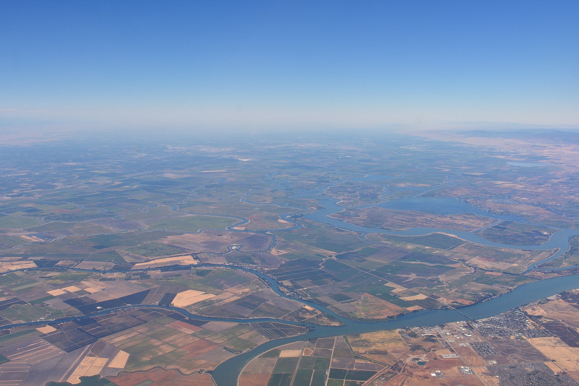
This is where you’ll find the Central Valley. For 400 miles north to south, and about 50 miles across, the land is stubbornly and mind-numbingly flat. Anyone who has driven this stretch of Interstate 5 (which I have) will attest to this. It’s a massive, unbroken table of sediment, completely surrounded by towering mountain ranges. But the Central Valley is so large that sometimes you can’t even see them.
So within the context of the wrinkley, bumpy American west, the Central Valley feels like it shouldn’t exist. So, how did this massive flatland get created? With all the mountains and earthquakes that create mountains, why and how does this region exist at all?
The missing plate
Well, speaking of those fault lines and earthquakes, we have to rewind about 100 million years to the Mesozoic Era. Back then, the West Coast of North America wasn’t a coastline, it was something called a subduction zone, or an area where one tectonic plate is squeezing itself under another.
Okay so back then there was a massive piece of the Earth’s crust called the Farallon Plate which was relentlessly diving underneath the North American continent (or what it was back then, everything looked a bit different of course). As this dense oceanic plate plunged into the mantle below, it melted. That magma bubbled up to the surface, creating a colossal chain of violent volcanoes (Hello Mt Hood! Actually no it’s pretty new but I like bringing it up whenever I can 😅). Anyways, the hardened, granitic roots of those ancient volcanoes are actually what we now call the Sierra Nevada mountains today.
But what happens in the space between the deep-sea trench where the plate is diving, and the volcanoes erupting further inland?
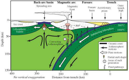
Geologists call this in-between zone a forearc basin. I had never heard of this term either and I love geographic terms. But basically, as the Farallon Plate scraped its way under North America, it created a massive depression just ahead of the volcanic arc. The Central Valley is the remnant of that ancient, sagging sea floor.
Now, having a large depression in the Earth’s crust is only step one. Step two is filling it in. And over the next tens of millions of years, the massive volcanoes of the ancestral Sierra Nevada were subjected to intense wind, rain, and ice. The mountains eroded, and all that rock, sand, and silt had to go somewhere. Rivers carried it downhill, dumping it straight into the sinking forearc basin to the west.
This process didn’t just happen for a little while though. It happened over millions of years. As the weight of the sediment piled up, the floor of the valley actually sank further, making room for even more dirt.
Today, the Central Valley isn’t just flat, it’s surprisingly deep. The bedrock lies buried beneath an astonishing three to six miles of sediment. That’s a lot of soil! That perfectly flat surface you see is just the very top layer of the sediment settling like water in a bathtub.
But here’s the kicker: for a long time, this sediment went into the ocean. This basin was actually a shallow inland sea, open to the Pacific Ocean, not a large bowl of land. But geology wasn’t done with California yet.
So now, roughly 30 million years ago, the tectonics changed once again. The Farallon Plate was almost completely swallowed up, and the boundary between the Pacific Plate and the North American Plate transitioned from a head-on collision to a side-by-side sliding motion which birthed the infamous San Andreas Fault, the most studied and documented fault line in the entire world.
The grinding, twisting forces of this new fault system began to squeeze the crust, pushing up the sea floor on the western edge of the basin. This rising land formed the California Coast Ranges which hug the west coast. And like a drawbridge pulling up, the Coast Ranges effectively sealed the valley off from the Pacific Ocean. The inland sea eventually drained and evaporated, leaving behind the incredibly rich, mineral-dense soils that had been collecting for millions of years.
The result of all this tectonic shuffling is a geography found nowhere else in the West.
Because it’s walled off by the Coast Ranges to the west and the Sierra Nevada to the east, the Central Valley acts as a giant atmospheric bowl. The Sierras catch the winter storms sweeping in from the Pacific, storing the water as a massive snowpack (at least during wet years). When spring comes, that snow melts, funneling fresh water directly into the deep, fertile soils of the valley floor.
It is a perfect, closed-loop system for agriculture, engineered entirely by blind geological forces. Today, this freak tectonic bathtub produces a quarter of the Nation’s food.
So, the next time you drive down I-5, completely bored by the endless flat land and lots of cows, take a moment to think about what a weird area this is. You’re driving over an ancient ocean trench, filled with the powdered remains of volcanoes, entirely walled in by tectonic collisions.
Enjoyed this. After living and working in the Bay Area, I retired to the northern part of the Valley. It is indeed quite a place. I grew up in rolling farmland back in the Midwest. This is not that.
Our food costs would be astronomical if not for the incredible output of the area. One percent of the country produces a quarter of our food. Pistachios, table grapes, tomatoes, almonds, and olives. Water is an issue, but the country is dependent on this region.