

The strange borders of Baarle-Hertog, a Belgian town within the Netherlands
Borders are kind of dumb.

Borders are strange things. They both exist in ways that effectively control the movement of people and goods, and yet they don’t really exist at all. A border can be placed along a river, of course, but that doesn’t make it more or less real than a border placed in an entirely open area. And the reason why I’m writing about borders today, though there’s certainly much more to be written about them, is because of a bizarre enclave of Belgium within the Netherlands. Its borders make no sense in the modern era and are, oddly, a remnant of some old medieval agreements that have managed to persist into today. Let’s check out the strange geography of Baarle-Hertog.
The strange borders of Baarle-Hertog
Baarle-Hertog is an enclave of Belgium that exists entirely surrounded by the country of the Netherlands. And while this is certainly a unique aspect of Baarle-Hertog, it’s not actually why I’m writing about this region today. Though it is worth explaining briefly what an enclave is. So let’s get to that first.
An enclave is almost exactly as I’ve explained it in the previous paragraph. It’s a piece of a country that would exist entirely within another country. Technically it’s both an enclave and an exclave, but that gets to a whole new level of geographic minutiae that I don’t want to dig too deeply into. But here’s a fun Storymap that explains it quite well! While it seems like something that would be rare, they’re actually not that uncommon, they’re just very very small and easy to miss. There are dozens of them throughout the world, and more if you start counting exclusive economic zones.
But let’s get back to Baarle-Hertog. Now, if you look at this map you’re going to immediately notice quite a few things:
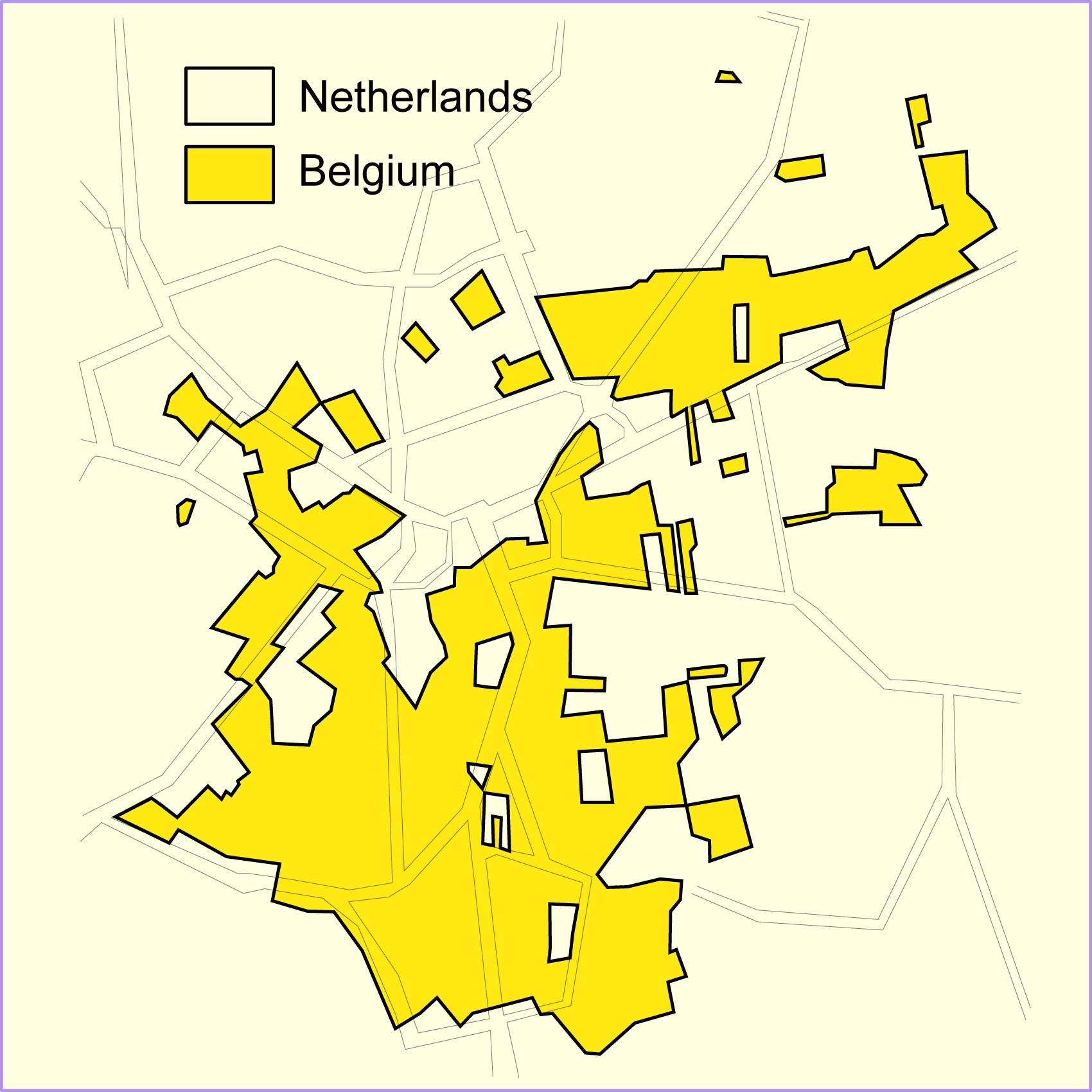
The first is that there doesn’t seem to be any rhyme or reason for why a border goes this way, or that way. Sometimes a border follows the road, sometimes not at all. It seemingly goes wherever it damn well pleases.
The second is that there are incredibly tiny pieces of each country’s territory within the other. Which means there are multiple enclaves and exclaves sort of embedding themselves. This is literally the Inception of geographic borders here!
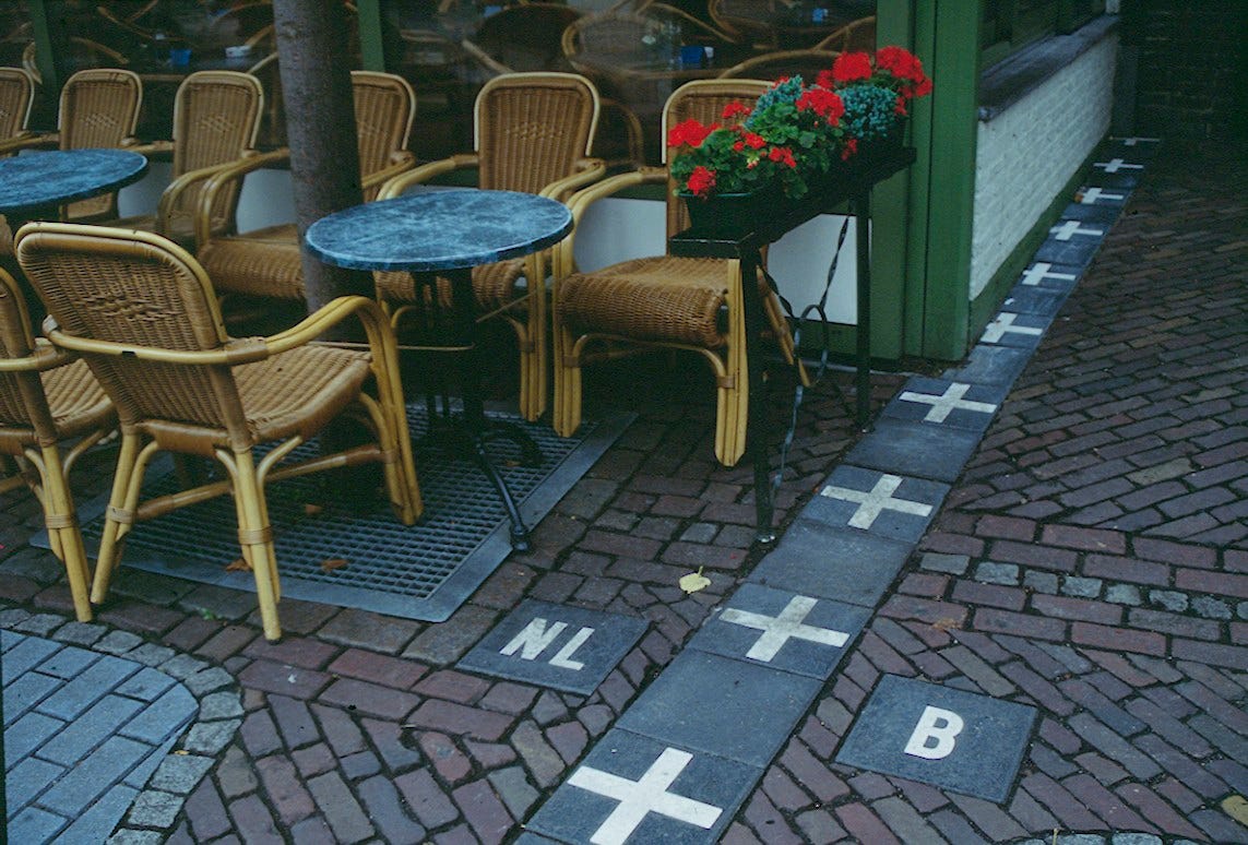
The final thing you’re probably going to notice is the scale of the map. Baarle-Hertog is very small. The entirety of the Belgian areas (yellow) is just under 3 square miles (about 7.5 square km). So some of those really tiny pieces are very likely a single plot of land with maybe a single building on it, and sometimes less. Walk in, and you’re in Belgium! Walk back out and you’re back in the Netherlands. Crazy right?
And it’s at this point you might be asking: well what’s the point of all this? Why not just fix the border and have the entire region absorbed into the Netherlands? While I don’t have a direct answer for you, though borders today within the European Union are not as important as they once were which makes this whole arrangement much easier, we can at least talk a bit about the history behind Baarle-Hertog.
According to what I can find, this tiny town is the result of a series of treaties, agreements, land sales, and land swaps between the nobility that controlled the then regions of Breda and Brabant. This, of course, meant that these deals were being made largely within the medieval and renaissance periods of Europe where such deals were often imprecise, overlapping, convoluted, and sometimes simply nonsensical. You can see where the problem originated…
Then, in the mid-1800s, after Belgium received its independence from the Netherlands, a treaty was signed between the two countries that firmly cemented the borders we see today. And Baarle-Hertog was left the way it is because the two countries simply couldn’t come to an agreement on how the land should be divvied up. Not exactly a perfect solution, but here we are.
How this all works today
Today, this border means less than it did a hundred years ago. Though truthfully, this specific border was probably never really enforced (how could it be?). But with the solidification of the European Union and the creation of the Schengen Zone, borders all across Europe sort of fell by the wayside. More a formality for most who lived within them than any sort of actual border like what a Canadian citizen would experience upon flying into France. But there have been some odd complications in recent years.
One such example has been how Belgium and the Netherlands handled the COVID-19 pandemic restrictions. Belgium didn’t allow citizens to patronize open restaurants and bars until later than the Netherlands. While this would be a relatively simple thing to enforce within the whole country of Belgium, within Baarle-Hertog technically a Belgian citizen who lived literally feet away from an open Dutch pub would be prohibited from going in and buying a pint. Again, how enforceable was this? That’s unclear! Likely not very, but it raises interesting issues for residents who might have to brave breaking the law if they wanted to partake in similar activities as their neighbors.
This of course cascades to a number of smaller laws. For example, Belgium has less restrictive laws around fireworks, making selling them within specific shops in Baarle-Hertog legal, despite the Netherlands having stricter laws. In some particularly odd cases, an entire building would be split in two and within those buildings would be a restaurant that would have to “close down” half its space due to laws around when things could stay open based on the other country’s laws.
All of this just leads back to the original point of this week’s article: borders are weird! They have so much control over our lives, but sometimes there’s little rhyme or reason why they exist aside from the fact that they’ve always been that way (as far as we’re concerned). Baarle-Hertog is just a very poignant example of that in action today.