

The "No Man's Land" of Western Sahara
It's almost always blank on a map
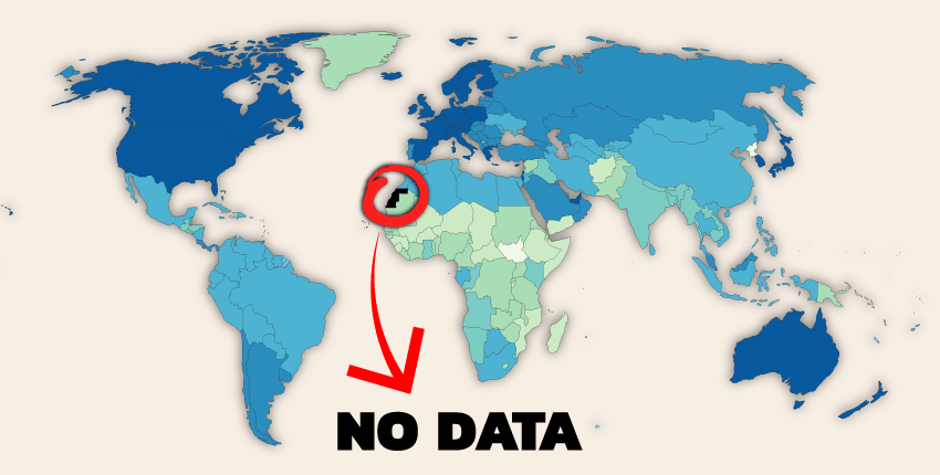
If you’ve ever looked at a data-driven map of Africa, you've probably noticed it. Tucked into the continent's northwestern corner, in between Morocco, Algeria, and Mauritania, lies a patch of land that is often colored grey. Whether the map displays population density, economic output, or health statistics, this territory frequently reads with "No Data." This is Western Sahara, a place that is anything but empty but its cartographic emptiness shows that something is amiss. So what’s going on with the place we know only as Western Sahara?
And, as usual, if you want to know more about Morocco (which will also feature heavily in this article btw) check out this week’s video:
Geographically, Western Sahara is defined by its namesake: the Sahara Desert. Which stretches through most of its territory to the resource-rich coastline along the Atlantic Ocean. And for centuries, this land has been home to the Sahrawi people, traditionally nomadic tribes with a unique culture and a distinct Hassaniya Arabic dialect. Which worked fairly well for them… right up until Europe turned its eye to the African continent.
In the late 1800s and early 1900s, as European powers carved up Africa, Spain claimed the territory (along with Morocco), eventually consolidating it as the colony of Spanish Sahara. For decades, it remained a remote outpost of Madrid's empire. But after World War II, decolonization swept across the globe and specific Africa. By the 1960s, a Sahrawi nationalist movement was growing, culminating in the formation of the Polisario Front, which demanded independence.
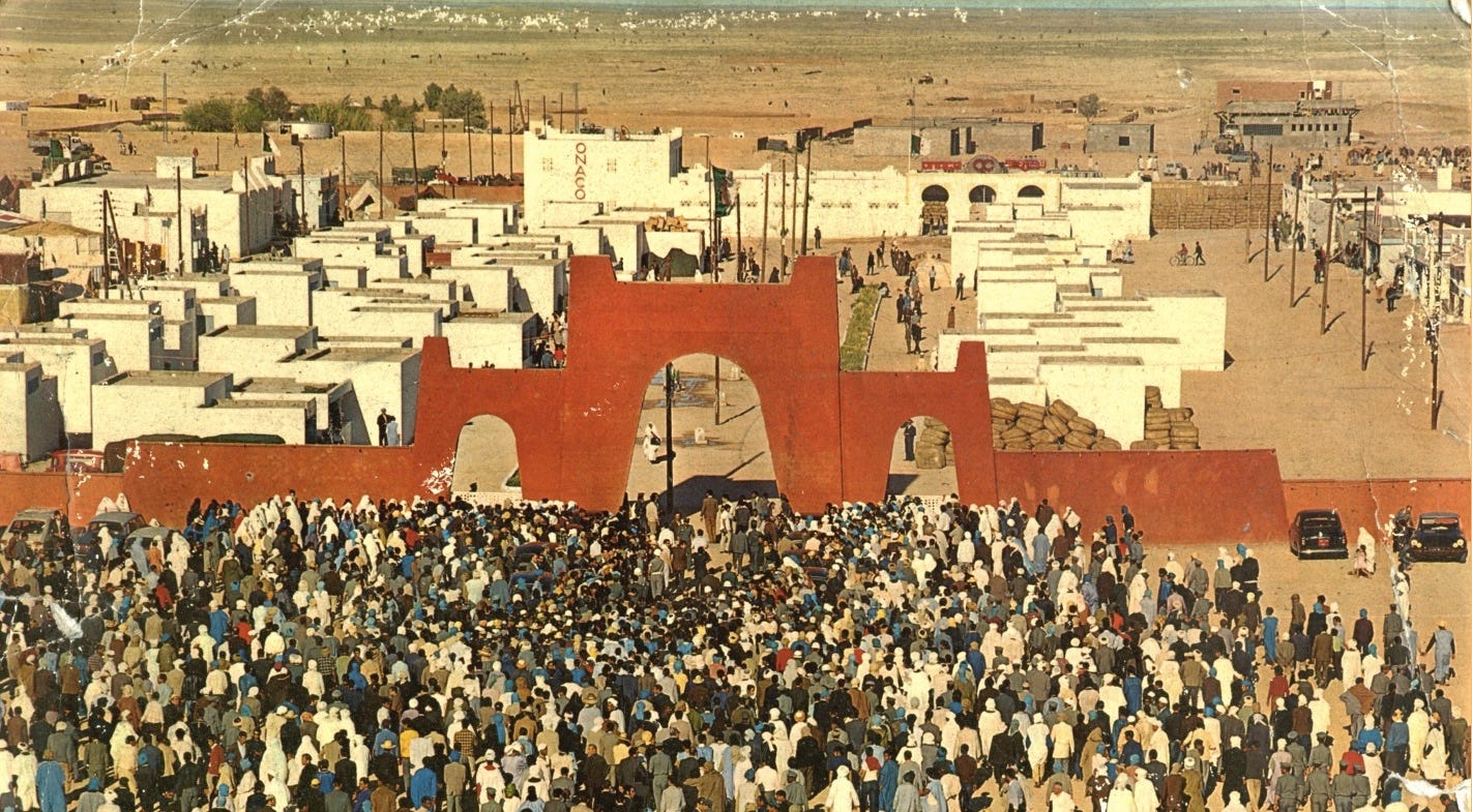
Now the critical turning point for Western Sahara came in 1975. As Spain, under the declining rule of Franco, prepared to withdraw, it didn't grant independence. Instead, it struck a secret deal with Western Sahara's northern and southern neighbors, Morocco and Mauritania. Morocco had long held a historical claim to the territory, viewing it as part of a pre-colonial "Greater Morocco." To solidify this claim, Morocco's King Hassan II orchestrated a pretty masterful piece of political theater: the Green March. He called upon 350,000 unarmed Moroccan civilians to march across the border into Western Sahara, overwhelming the Spanish authorities and effectively asserting Moroccan control.
And it largely worked! Spain withdrew and, when they did, Morocco officially annexed the northern two-thirds of the territory, while Mauritania claimed the southern portion. Meanwhile, the Polisario Front (the Sahrawi nationalist organization), backed by neighboring Algeria, fiercely resisted. They declared the establishment of the Sahrawi Arab Democratic Republic (SADR) and launched a guerilla war against both occupying powers, Morocco and Mauritania. After a few years of costly conflict, a weakened Mauritania relinquished its claim in 1979. Morocco promptly moved in, annexing the southern part as well.
The war raged on until the 1980s, when Morocco constructed one of the most formidable defensive structures on the planet: the Moroccan Wall, or "Berm." This is a massive, 2,700-kilometer-long sand wall, fortified with landmines, fences, and military posts. It effectively sealed off the economically valuable western part of Western Sahara—containing all the major cities and phosphate mines—from the sparsely populated, Polisario-controlled interior.
This physical division led to a political stalemate. In 1991, the United Nations brokered a ceasefire. But the agreement came with a critical promise: a referendum that would allow the Sahrawi people to vote on their future, choosing between independence or integration with Morocco. Ths never actually happened though. Instead decades have been lost to disagreements over who is eligible to vote, a delay that has left the situation frozen (ironically enough given the geography).
This frozen conflict is precisely why Western Sahara appears as a blank space on so many maps. The international community is deeply divided. The Sahrawi Arab Democratic Republic is recognized as a sovereign state by dozens of countries and is a full member of the African Union. Morocco, however, rejects this and considers the territory its "Southern Provinces." Major world powers, like France and the United States, have historically supported a UN-negotiated political solution without formally recognizing Moroccan sovereignty.
This lack of consensus creates a dilemma for international organizations, corporations, and cartographers. To label the territory as "Morocco" would be to take a political stance against the SADR and the UN's position. To label it "Western Sahara" or "SADR" would be to anger Morocco, a major regional power with a growing economic base that’s otherwise a very stable entity in a increasingly chaotic region. Faced with this geopolitical minefield, many countries and entities simply choose neutrality. The "no data" or greyed-out area is a visual representation of this. It signifies a territory whose final status is “TBD.” It's the cartographic equivalent of a legal case still pending in the world's highest court.
Today, the situation remains tense. The 1991 ceasefire officially broke down in late 2020, and low-level hostilities have resumed. Nothing major, mind you, but it’s getting much more tense. And the political landscape shifted significantly when the United States, under the Trump administration, recognized Moroccan sovereignty over Western Sahara in exchange for Morocco normalizing relations with Israel—a policy the Biden administration didn’t reverse and the second Trump administration also hasn’t reversed. Furthermore, more and more countries such as Spain, the United Kingdom, and France are increasingly agreeing with Morocco’s plan for a controlled, but autonomous region for Western Sahara.
All that’s to say, though, the territory remains physically and politically split by the Berm. West of the wall, Morocco has invested heavily in infrastructure, encouraging Moroccan settlement and developing the region's fishing and phosphate industries. East of the wall lies the "liberated territory" controlled by the Polisario Front. Beyond that, in the harsh desert of southwestern Algeria, hundreds of thousands of Sahrawi refugees live in camps near the city of Tindouf, where they have been for nearly five decades, subsisting on international aid.
So, the next time you see that blank spot on a map of Africa, know that it’s not actually empty, but it is complicated.
It isn't empty, but under populated. It is the minerals underground that both Spain and Morocco were after. The country of Western Sahara is an independent country. Although a fine piece of geo history.