

The Great Plains are losing their largest water source... fast
Why aren't we talking more about the Ogallala Aquifer?

I talk quite a bit about droughts and lack of fresh water. As someone who lives in the west (even if its the rainier, drearier side of the Pacific Northwest) the reality is that we, as a society, simply use too much fresh water basically everywhere. The Colorado River is something that is probably immediately jumping to mind for all the obvious reasons: it’s the most talked about and its issues are the most acute.
But recently I decided to ‘dive in’ to another big and upcoming water issue. One that’s not centered around a river, but rather one of the largest and most important underground aquifers on the entire planet. This is an underground ocean of water so large that it would be larger than every single state in the United States, except for Texas and Alaska. In fact, it’s nearly twice the size of the combined size of ALL Great Lakes. Needless to say, it’s a lot of water. Or rather it was a lot of water because, as of today in 2026, it’s being rapidly depleted.
And of course this ties in nicely with my video this week all about why the United States’ geography is breaking down. You can catch in on YouTube right here:
OR if you’re a paying subscriber, check out the ad and sponsor-free video right here.
And with that, let’s get into this thing we call the Ogallala Aquifer, which is quite the jumbly mouth-full!
What is the Ogallala Aquifer?
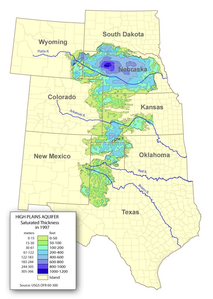
The Ogallala Aquifer (often referred to interchangeably with the broader High Plains Aquifer system) is a vast, unconfined underground water table spanning beneath eight states: South Dakota, Nebraska, Wyoming, Colorado, Kansas, Oklahoma, New Mexico, and Texas. It actually formed millions of years ago (well before humans were a thing) and the aquifer itself is essentially more of a massive sponge of gravel, sand, and silt holding ancient fossil water dating back to the last Ice Age.
And as you can tell by the map above, it’s quite expansive with the majority of its reserves lying underneath Nebraska (who knew?). But because the region sits in a semi-arid climate where evaporation often outpaces rainfall, the aquifer receives very little natural recharge. Basically: when water is pumped out, it’s effectively being “mined” with no way of replacement. Like if you mined out all the gold in a mountain, the gold won’t just naturally recharge. It’s gone… poof!
Unsurprisingly, this has been a HUGE boon for the geography of the entire United States. After all, the Great Plains has become one of the great agricultural regions of the world. Unfortunately, this also means that it’s being drained.
Watering the Great Plains

Okay, so before the mid-1900s, farming in the Great Plains was a high-risk gamble dependent entirely on unpredictable rain. This is largely the same area that culminated in the devastating and infamous Dust Bowl of the 1930s, after all. Needless to say, any change in weather patterns would greatly hamper any agricultural output. This was also well before there was any serious water extraction from the Ogallala Aquifer. There was probably some but nothing on any industrial scale as far as I can tell. But that would change after the Dust Bowl and then World War II.
After the war, a couple new irrigation technologies became widely adopted: the center-pivot irrigation and high-powered groundwater pumps. This changed EVERYTHING for the Great Plains. Farmers could suddenly pull deep, reliable water to the surface, transforming the landscape into some of the most productive agricultural land on Earth.
Today, the numbers tied to the Ogallala are incredible. It provides roughly 30% of all groundwater used for irrigation in the United States. Like not just the Great Plains… the entire country. It also supports nearly one-fifth of the nation’s total agricultural output, including massive yields of corn, wheat, cotton, and soybeans. And finally, it acts as the foundation for the region’s livestock, dairy, and meatpacking industries, which rely heavily on irrigated feed crops like corn and alfalfa.
Basically, without the Ogallala, the Great Plains simply can’t sustain its current level of food production.
Which leads us to 2026…
The well is running dry
The modern reality of the Ogallala Aquifer is one of steady depletion. But because the aquifer isn’t a single open underground lake, but rather water trapped in rock and sand, it’s not draining evenly. Some northern areas, like parts of Nebraska, still have thick, healthy water reserves whereas the central and southern plains are facing a severe crisis.
Here’s some recent data points that I could find:
A 2026 report from the University of Nebraska-Lincoln found that following years of persistent drought, 62% of measured wells in Nebraska recorded declines. Further south, the situation is even more acute where southwest Kansas lost 1.52 feet of water in 2024 alone, marking its steepest single-year drop yet. Yikes! UNL also happens to be the location of the national drought monitor so I believe they know what they’re talking about.
Meanwhile, in heavily pumped areas like the Texas Panhandle, projections from the University of Texas Bureau of Economic Geology suggest that up to 70% of the area’s groundwater could become unusable within roughly 20 years at current extraction rates.
But also, the depletion isn’t just an environmental issue, it’s a financial one. A 2025 USDA study (same link above) shows a direct correlation between falling water tables and rising farm loan delinquencies. Which make sense because, as wells run dry, farmers are forced to drill deeper, increasing the energy costs to pump the water.
Finally, high-water industries are colliding with the reality of the aquifer’s limits. Massive new dairy processing expansions in Kansas are currently drawing heavily from some of the thinnest parts of the aquifer, forcing lenders and farmers to weigh short-term profits against a rapidly shrinking long-term water supply.
And so there you have it! The United States' was blessed with one of the largest underground aquifers in the world. Much like it was blessed with large amounts of coal, oil, gold, and other incredibly valuable natural resources. But unlike those other resources, this is one that we all need to survive. Even if you don’t necessarily live in the region and use the water directly, you probably do indirectly either through the food you eat or some other manufactured or industrial product that goes into your community. Which means, if this well does eventually go dry, we’ll all pay the cost in one form or another.
Do you live here? Is this something people in the region are talking about? I’d love to hear in the comments!
As a Geography Information Systems major back in the 80's one of the projects I worked on as an undergraduate was mapping the center pivot irrigation systems out in the panhandle of Oklahoma. We used at that time Landsat imagery to denote the differences in years apart data. We noted at least a doubling effect of the CPI's and I would hazard to say dipping into that particular water source.
Glad to find fellow geographers! Gail
Hello Geoff, I am interested in the topics to which you refer in the video on the blessings of the United States. But I am not impressed by the somewhat hysterical presentation that is like the material routinely presented on TV sources that highlight the most negative aspects of the happenings every day. To make things better, it is almost always necessary to quantify the fundamental quantities that affect whatever is under consideration and consider quantitatively at least their rates of change and determine the means, if any, that can be brought bear that would change the trajectory of the systems under consideration. If it is feasible to make adjustments that will affect the trajectory, then a discussion of pros & cons might be productive. If you are going to provide information on geographical systems that contributes to such a discussion, I will stay with you. If not, then I will be departing. An example of quantification that I do not consider helpful is to say that the Ogallala Aquifer provides 1/5 of the ground water used in the United States when there are current efforts to increase efficiency by monitoring fields with resolution sufficient to provide very local distribution as needed by individual plants as compared to massive overwatering at times up to now.