

The American Nations by Colin Woodard
Is the United States one nation or eleven nations?

So over the weekend something interesting happened. An older Substack that I no longer write at, starting getting quite a lot of traffic. Nothing earth-shattering mind you, but for a newsletter that hasn’t been updated in about 13 months, it was significant. And all that traffic focused on a series of maps I made that illustrated and explained the regions Colin Woodard wrote about in his book American Nations (complete with my awful old watermark 🤢).
Anyway, since that post was blowing up, I figured I might as well share it with you all so you can see what all the fuss is about. I do want to make one thing clear though: while I find Colin’s ideas intriguing, I don’t necessarily agree with them. There are some things within his created regions I think are incorrect, especially in 2023. Still, they’re interesting ideas and ones we should at least consider even if critically. Plus, who doesn’t enjoy a good cultural regions discussion? 😅
The following article is mostly the same as the one found on The Map Stack, but has been edited for clarity.
What are the American Nations?
Written by Colin Woodard and published in 2011, American Nations is a book that attempts to explain the unique dichotomies between various regions in the United States. In it Colin suggests that the United States is actually eleven separate nations joined by a single governmental body. And within the single body, each nation is in a constant state of competition with the others for cultural, ideological and political supremacy. Some have natural alliances with each other, while others are considered to be rivals.
Basically the theory goes that each region is more culturally bound to itself that it is to the other nations, much in the same way that the European Union is comprised of 27 nations. And while the United States often speaks as one voice externally, who gets to control that voice - and what the message is - depends on which nation, or group of nations is currently more powerful at the moment.
Suffice it to say, the theory is definitely interesting. I won’t get too far into critiquing the theory at the moment, but I see both merits and faults in what Woodard is proposing. At the very least, it’s an entertaining idea that we can use to help explain the diversity and complexity of the United States.
Before I get into each nation and even list them off, I want to begin with a caveat. If you’ve already read Woodard’s book, or plan on reading it soon, you’ll notice I’ve made a few changes. The first is that I’ve opted to portray the nations as being from the United States only. This means that El Norte doesn’t bleed into Mexico, nor the Left Coast into British Columbia. New France also no longer includes Quebec. For this reason I’ve also opted to leave out the ‘First Nations’ nation that Woodard writes about.
I’ve done this simply because it’s very challenging to gather data on three different countries and use them comparatively. While I love doing this kind of stuff, at some point I just don’t have the time. As such, you’ll also notice that, in the place of the First Nations nation, I’ve included Hawaii and the Spanish Caribbean as their own nations. This technically brings us up to 12 nations in total, which I am cognizant of, but since the theory largely centers around the “11 nations” I’ve opted to continue with that verbiage.
With that out of the way, here are our American Nations (in no order):
Yankeedom
New Netherlands
Tidewater
The Deep South
The Midlands
Greater Appalachia
New France
The Far West
El Norte
The Left Coast
Spanish Caribbean
Hawaii
Yankeedom
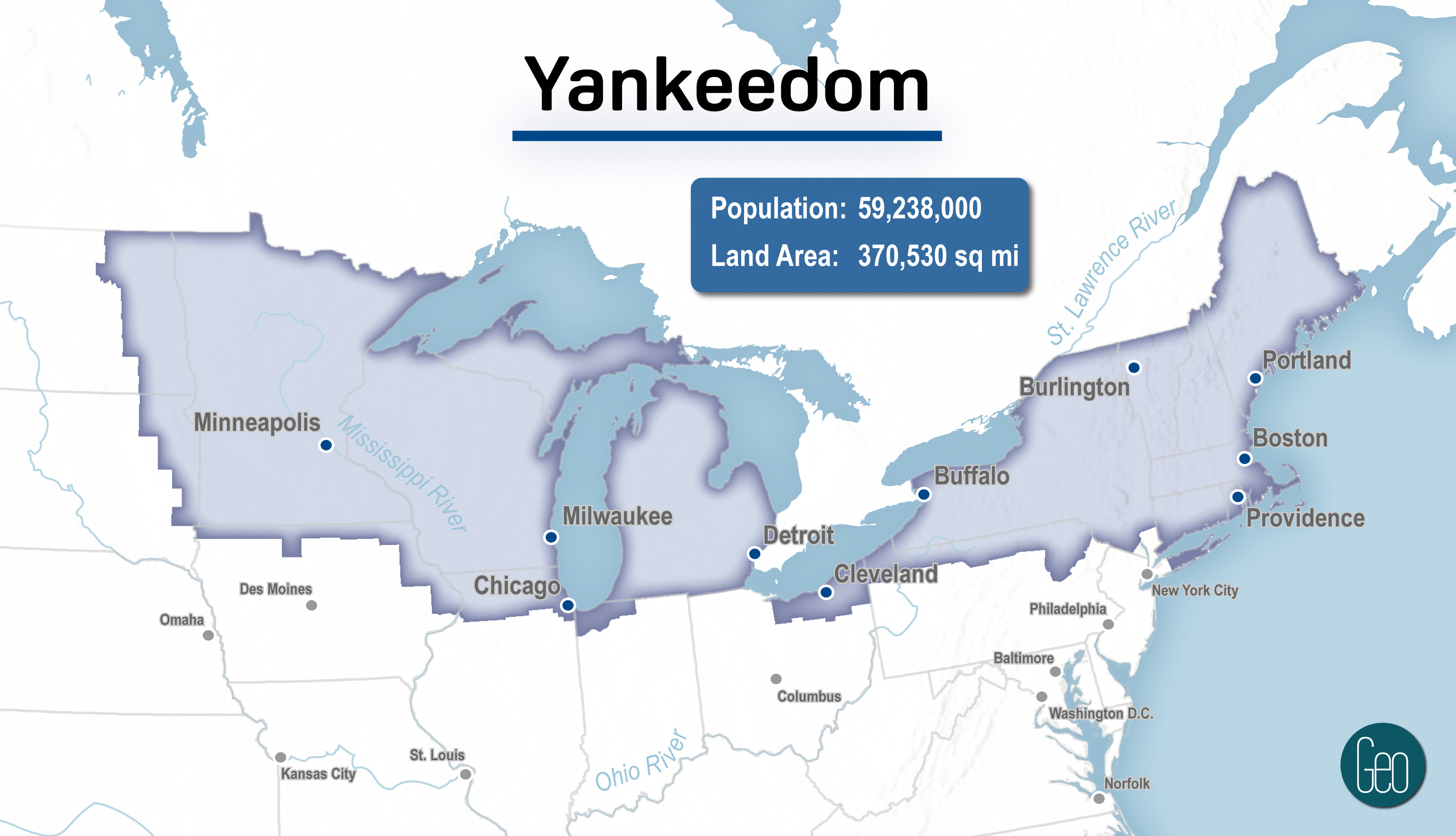
Population: 59,238,000
Area: 370,530 square miles
Ideological allies: The Left Coast, New Netherlands, Hawaii
What Woodard has to say:
Yankeedom began with the Puritans (Calvinist English settlers) in New England and spread across upper New York, the northern parts of Pennsylvania, Ohio, Indiana, Illinois, and Iowa, into the eastern Dakotas, Michigan, Wisconsin, Minnesota, and the Canadian Maritime. The area values education, communal decision-making and aims at creating a religious utopian communal society to be spread over other regions.
Again, this being 2023, I think this nation would look quite different. I’m not sure how ideologically aligned Michigan is with Massachusetts, for example.
New Netherlands

Population: 17,632,000
Area: 5,297 square miles
Ideological allies: The Left Coast, Yankeedom, Hawaii
What Woodard has to say:
New Netherlands, established by Dutch colonists in the 17th century, is now Greater New York City, as well as the lower Hudson Valley, northern New Jersey, western Long Island, and southwestern Connecticut. The area promotes liberal, multicultural values, capitalism and the freedom of the press.
The smallest nation by area size and the densest in terms of population by far.
Tidewater

Population: 12,440,000
Area: 46,321 square miles
Ideological allies: Greater Appalachia, The Deep South
What Woodard has to say:
Tidewater was founded by Cavaliers (Royalists during the era of the English Civil War and Stuart Restoration), and consists of Virginia, Maryland, southern Delaware, and northeastern North Carolina. Has cooperated often with Deep South and Greater Appalachia. Together with George Washington, many of the Founding Fathers came from here. Appalachian mountains cut its expansion westwards, and the region is now being overrun by the Midlands.
I’m actually unsure if Washington D.C. should be included in Tidewater. According to Woodard, Tidewater is ideologically aligned with The Deep South, but Washington D.C. is far more progressive.
The Deep South

Population: 45,268,000
Area: 318,785 square miles
Ideological allies: Tidewater, Greater Appalachia
What Woodard has to say:
Deep South was settled by former Anglo-American West Indies plantation owners in Charleston, and spread to encompass South Carolina, Georgia, Alabama, Mississippi, Florida, Louisiana, western Tennessee, and the southeastern parts of North Carolina, Arkansas, and Texas. It values old Greco-Roman enlightened, civilized, idle slave society, free-markets and individual freedoms. It has fought centuries with Yankeedom over the dominance of North America, such as in the Civil War and the "culture wars" started by the civil rights movement since the 1960s.
The Midlands

Population: 35,785,000
Area: 301,087 square miles
Ideological allies: The Far West
What Woodard has to say:
Midlands, founded by English Quakers followed by the Pennsylvania Dutch, consists of southeast Pennsylvania, southern New Jersey, northern Delaware and Maryland, central Ohio, Indiana and Illinois, northern Missouri, most of Iowa, and the eastern halves of South Dakota, Nebraska, and Kansas, as well has southern Ontario. The border city of Chicago is shared with Yankeedom and St. Louis with Greater Appalachia. Midlands promotes peaceful values and has often been in several elections the great swing-region between Yankeedom and the Southern Nations. According to Woodard it is culturally the most "American" of the nations.
Woodard actually doesn’t ascribe The Midlands and The Far West as ideological allies, but I feel they share enough similarities to make it the case here. In particular the western end of the Midlands feels very much like the Far West to me.
Geographically, this nation also makes the least amount of sense. It’s almost like a gerrymandered nation where Colin couldn’t quite figure out what to make of it all.
Greater Appalachia

Population: 59,774,000
Area: 547,005 square miles
Ideological allies: The Deep South, Tidewater
What Woodard has to say:
Greater Appalachia was populated by waves of immigrants that Woodard calls Borderlanders, from the borders of Northern Ireland, northern England, and the Scottish lowlands. Greater Appalachia covers the highlands in the south United States, the southern parts of Ohio, Indiana, and Illinois, the Ozarks of Arkansas and Missouri, eastern Oklahoma, and Texas Hill Country. Its fighting spirit is embodied by figures such as Davy Crockett, Andrew Johnson and Douglas MacArthur.
Greater Appalachia including Texas and New Mexico? That’s just nuts.
New France
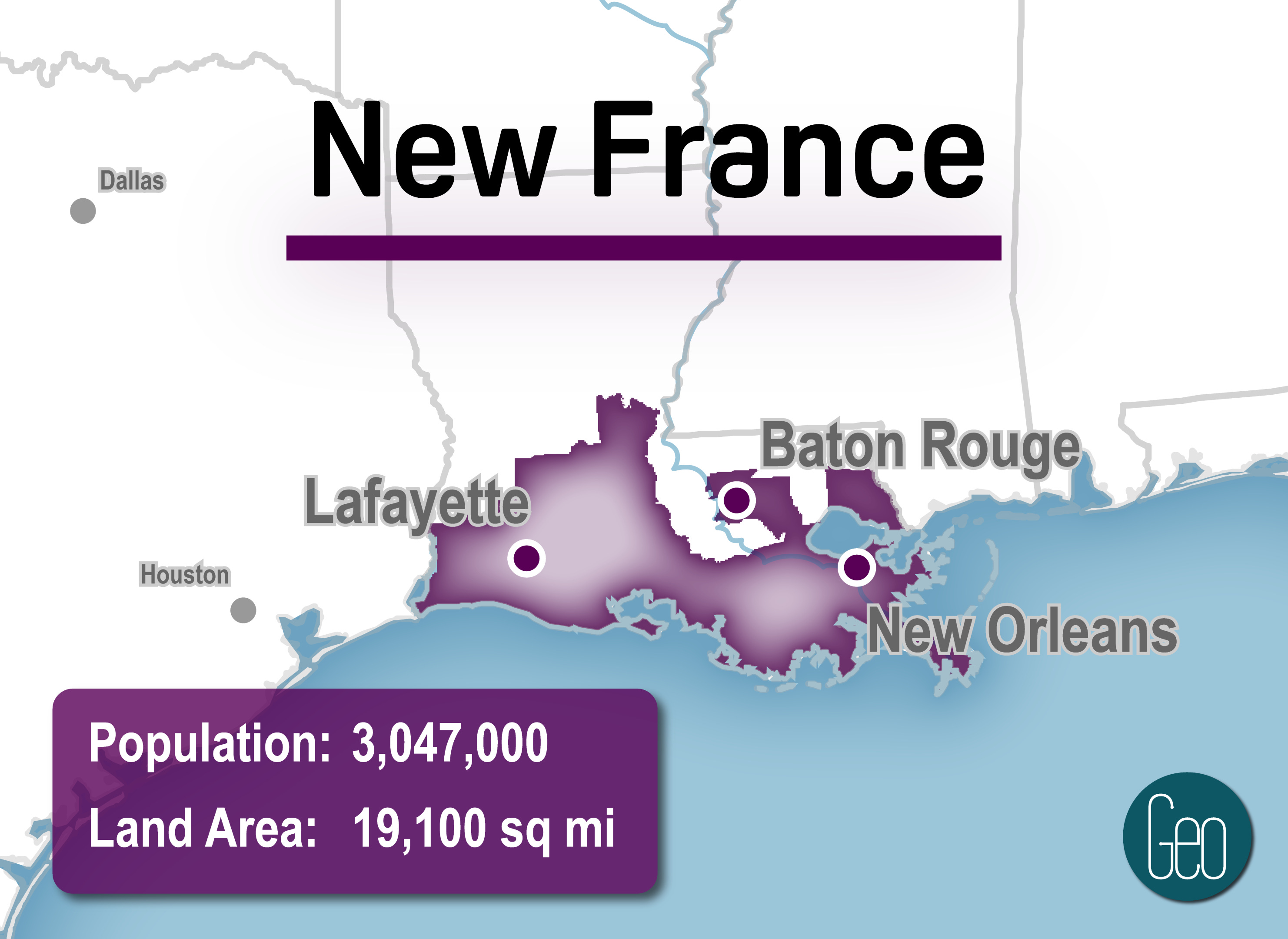
Population: 3,047,000
Area: 19,100 square miles
Ideological allies: Not sure
What Woodard has to say:
New France began in 1604 with an expedition from France led by Pierre Dugua. It grew to encompass the lower third of Quebec, north and northeast New Brunswick, and southern Louisiana.
It’s a little challenging to discuss New France without its Canadian parts. Woodard relies heavily on those areas to engage in the discussion of New France and we don’t have that luxury here. Still, the southern parts of Louisiana are definitely unique in their own way. I’d argue they’re culturally and significantly unique enough from their French Canadian roots as well.
The Far West

Population: 29,531,000
Area: 1,636,445 square miles
Ideological allies: The Midlands
What Woodard has to say:
Far West is the interior of the United States and Canada west of the 100th meridian west between El Norte and First Nation. It includes the interiors of California, Oregon, and Washington, much of British Columbia, Alberta, Saskatchewan, Manitoba, and Alaska, part of Yukon and Northwest Territories, the west halves of the Dakotas, Nebraska, and Kansas, as well as Idaho, Montana, Colorado, Utah, and Nevada. The region has been "imperialized" by other nations, such as Yankeedom and Deep South with large mining and infrastructure projects. The Mormon Enclave has been its politically most influential group.
Interesting note: The Far West is the start of many of the the United State’s major rivers (Snake River, Missouri River, Colorado River, Arkansas River, Rio Grande). The Columbia doesn’t start there but a long portion of it runs through The Far West as well.
El Norte

Population: 34,062,000
Area: 221,547 square miles
Ideological allies: Potentially Spanish Caribbean
What Woodard has to say:
El Norte is where the oldest European subculture in the United States is found, from the early Catholic Spanish settlers in the 16th century. Later augmented by Anglo-Americans from Deep South and Greater Appalachia, it includes south and west Texas, southern California and its Imperial Valley, southern Arizona, New Mexico, parts of Colorado, and the Mexican states of Tamaulipas, Nuevo León, Coahuila, Chihuahua, Sonora, and Baja California.
Woodard includes much of northern Mexico in his theory. Again, for data reasons, I’m just looking at the United States.
The Left Coast

Population: 18,405,000
Area: 105,508 square miles
Ideological allies: New Netherlands, Yankeedom, Hawaii
What Woodard has to say:
Left Coast was predominantly settled by Yankees from New England, with a huge influx from Greater Appalachia and countries around the world when gold was discovered. It encompasses the land between the Pacific Ocean and the Pacific Coast Ranges from Monterey, California to Juneau, Alaska, containing parts of California, Oregon, Washington, British Columbia, and Alaska. It is an ideological ally with Yankeedom and El Norte.
Quick note: obviously British Columbia and Vancouver in particular would be included here given their closeness to Washington and Seattle, but again I’ve opted not to include them.
Spanish Caribbean

Population: 11,407,000
Area: 16,890 square miles
Ideological allies: Potentially El Norte
The Spanish Caribbean is not included in any meaningful way in American Nations and so no quote from Woodard is provided. I’ve opted to include them because it’s a significant cultural region of the United States. I’ve also opted to include southern Florida with Puerto Rico. There may be issues with that given the presence of Cuban-dominated culture in southern Florida, but I think there are enough Caribbean ties to make it work.
I’ve also have them as a potential ideological ally of El Norte. Make no mistake. Norteno culture and Caribbean culture are very different, but the shared language of Spanish binds them together in the same way English binds the USA and UK together.
Hawaii
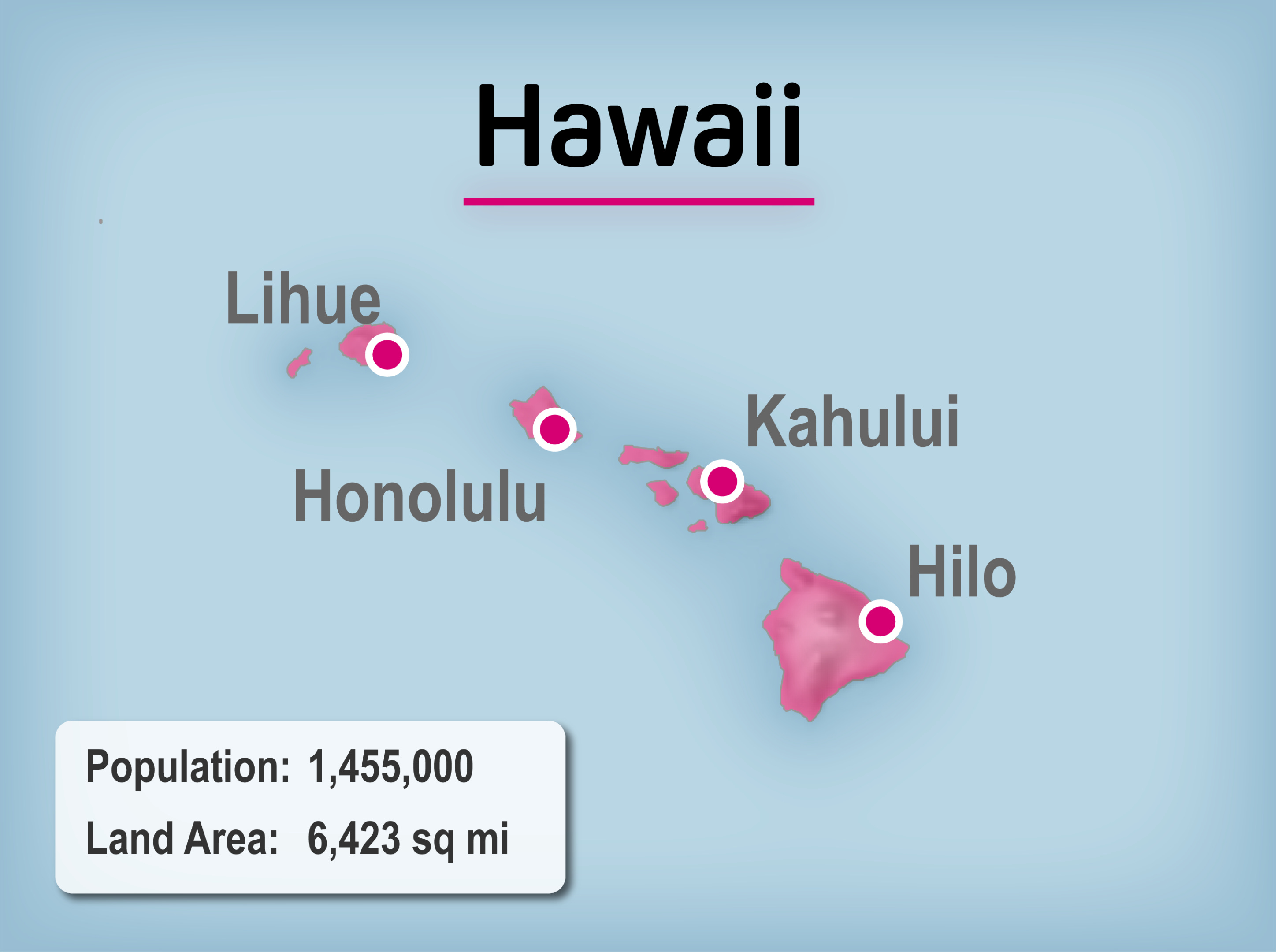
Population: 1,455,000
Area: 6,423 square miles
Ideological allies: The Left Coast, Yankeedom, New Netherlands
Hawaii is not included in any meaningful way in American Nations and so no quote from Woodard is provided. Hawaii is an interesting nation otherwise, though, and I’m surprised Woodard left them out. After all, Hawaii was a modern nation (for its time) when the United States forcibly annexed it in 1898 and its Hawaiian culture is still very dominant on the islands.
So there you have it: the American Nations by Colin Woodard! Fun ideas but probably ones lost to time. At the very least, I hope you enjoyed the pretty maps of each!
The first to do a project like this was Joel Garreau back in the 1980s. Woodard modified it by taking into account the work of David Hackett Fischer in Albion’s Seed. (As a geography man, you should be familiar with both of them!) But Woodard, unlike Garreau, never explained why he drew the borders the way he did. For example, he puts the San Joaquin Valley and San Bernardino County in the Far West. Garreau put them in MexAmerica, and Garreau is right. I can testify as a Californian. BTW why do you do so few articles about California?