

Oklahoma's strange panhandle
It's one of the oddest state border anomalies out there
State borders are weird. As the United States was carving up its acquired and annexed land, it made some questionable decisions in the geographic arrangement. Where European countries look all squiggly, often times following natural features, or following a centuries-old borders from long-removed nobility, the states of the United States were more bureaucratically arranged than anything else. Oftentimes this was done under the guise that one group of people didn’t want to to be associated with another. Anyway, I could go on and on about this. And I did! In this week’s video:
But this article is all about Oklahoma, which is NOT featured in the video above. Not because it’s not a weird one, but because I’m trying to give Substack extra bits of information rather than regurgitating my videos. So expect this to be the case going forward.
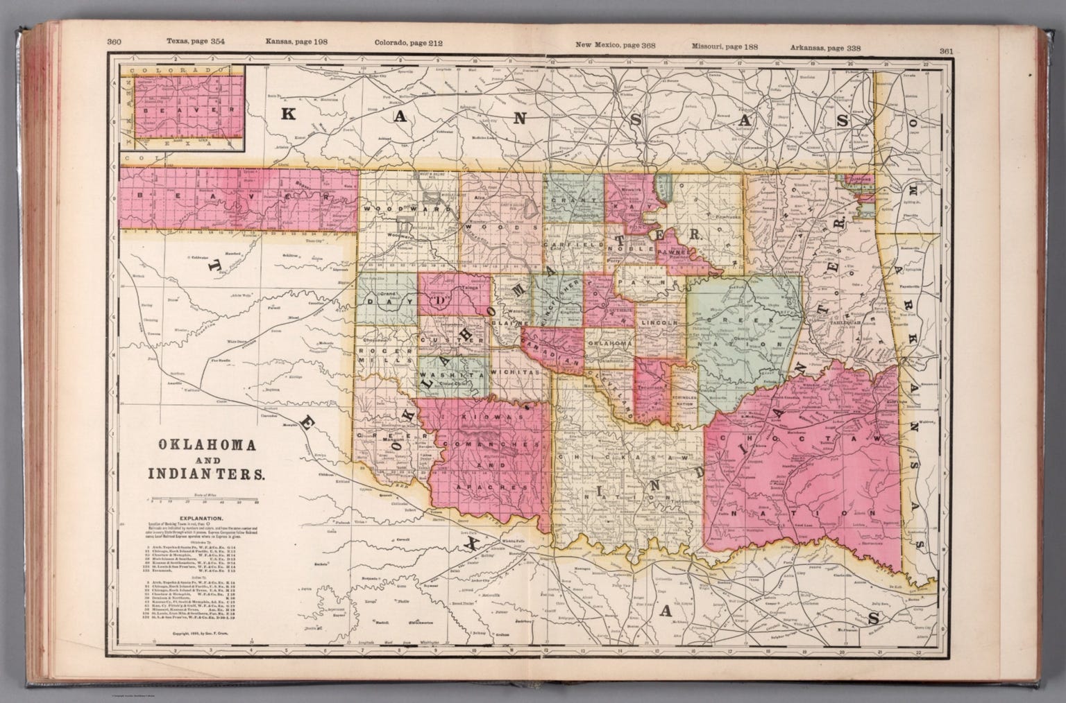
Oklahoma’s weird panhandle
Imagine you're looking at a map of the United States. Texas, a vast, sprawling state, appears to logically encompass that northern sliver. It's flat, arid, and shares more in common with the Lone Star State than the rolling hills and plains of central Oklahoma. So, what happened?
To understand Oklahoma’s panhandle, we need to rewind to the early 1800s, a time of shifting territorial borders, political maneuvering, and war. Texas, then part of Mexico, was a region ripe for expansion. The newly independent Mexico was very fond of its northern territory and saw it as a place it needed to settle in order to maximize its economic potential. Unfortunately for Mexico, there wasn’t a whole lot of interest amongst Mexicans to traverse the expansive deserts to get there. So, in orer to boost its population, Mexico appealed to Americans. In exchange for land, Americans could move to Mexico’s Texas and start the process of making the region economically viable. But this migration came with a hitch: in 1837 Mexico abolished slavery, something the Americans who had been moving into Texas, did not want.
Enter the Republic of Texas, which won a grueling war of independence from Mexico primarily so that the state could continue the practice of owning slaves. And after gaining independence from Mexico in 1836, Texas claimed a vast territory extending to the far north, extending as far north as what would become the state of Wyoming.
This claim, however, was a point of contention with the then United States. The Missouri Compromise of 1820 had established the 36°30' parallel as the dividing line for slavery in territories west of the Mississippi River. Land south of this line could become slave states, while land north was to be free. When Texas joined the United States in 1845, the issue of its northern boundary became a critical part of the annexation agreement.
The Compromise of 1850 finally settled the matter. In exchange for relinquishing its claims to land north of the 36°30' parallel, Texas received $10 million to pay off its debts. This compromise effectively "chopped off" the northern part of Texas, creating a narrow, unclaimed strip of land. This strip, stretching about 167 miles long and 34 miles wide, became known as "No Man's Land."
"No Man's Land" was a wild and lawless frontier. It was a haven for outlaws, squatters, and those looking to escape the reach of established governments. With no official jurisdiction, it became a sort of Wild West free-for-all. This period of lawlessness persisted for several decades, adding a colorful, if chaotic, chapter to the region's history. In fact, much of the United State’s collective imagination of the “Wild West” was due to this specific area where laws were loose at best.
But that’s how Texas lost it’s northern territory, including the region that would become Oklahoma’s weird panhandle. So how did Oklahoma acquire it?
Oklahoma, in its early days, was not a single entity. The area that would become Oklahoma was a patchwork of territories, including the "Unassigned Lands" and the "Indian Territory" (not to be confused with Indiana which was also an Indian Territory of sorts before Oklahoma). The Unassigned Lands, a central portion of what is now Oklahoma, were opened to white settlement through a series of land runs, most notably the Land Run of 1889. Few cities and regions ever just appear over a single day, but Oklahoma, and Oklahoma City did!
The panhandle, still "No Man's Land" at this time, continued as a separate entity, not yet officially part of Oklahoma. But as Oklahoma's territories began to coalesce, the question of the panhandle's status arose. The people living there, tired of the lawlessness and lack of government services, sought to be incorporated into a larger territory.
In 1890, the Oklahoma Organic Act established the Oklahoma Territory, and "No Man's Land" became Beaver County, part of this newly formed territory. It was a logical move, given the practical realities of governance. The panhandle was geographically isolated from Texas, who’s primarily population was situated in the far east and south, and its residents had more in common with the settlers in the developing Oklahoma Territory. Additionally, during this time of territorial management, it was much easier to become part of a territory than part of a state. State boundaries were set and changing them, especially during this time so soon after the Civil War, was not something anyone was really looking to do.
Now, you might be thinking at this point: “Well why did it go to Oklahoma instead of a split between Colorado and Kansas?" And it’s a good question! Both territories are older and were more established. It would have made a certain amount of sense, but there’s a very good reason for this, particularly as it pertains to Kansas.
In 1854, the Nebraska-Kansas Act was signed, which formally divided the larger Unassigned Lands into Nebraska and Kansas respectively. The southern border of Kansas, it was stated, would be set at the 37th parallel. Remember, during this time, what would become Oklahoma was being designated as Indian Territory. It was also during this time that Kansas was having a pretty tumultuous moment. Pro-abolitionists and pro-slavery fought extensively throughout the state leading to a period now known as “Bleeding Kansas.” Basically, Kansas as a territory in the early years was in a rough spot, and not many people were looking to join with a territory that appeared to have a mini-civil war on its hands. When all was said and done, Kansas’ borders remained firm without much desire to expand itself. Southeast Colorado, at this time, was part of the Kansas territory.
This all left the panhandle with one option: tie itself to the bourgeoning Oklahoma Territory! When Oklahoma achieved statehood in 1907, the panhandle became part of the state as well. The geographical oddity, born from political compromises and historic quirks, was now firmly within Oklahoma's borders.
So, why does Oklahoma have a panhandle? The answer lies in a complex interplay of historical events. The Missouri Compromise, the Texas annexation, the Compromise of 1850, the Kansas-Nebraska Act of 1854, and the Oklahoma Organic Act all played crucial roles.
Today, of course, it’s ahrd to imagine Oklahoma without its signature panhandle. But, when you look at it just a little bit more closely, it does seem like an illogical addition. One better suited to either Texas, or a split between Colorado and Kansas.
Geoff, thank you for introducing me to new panhandles. Also I have questioned if Colorado and Wyoming were perfectly square and now I know they are not. Have wondered that for many moons.
One of your finest geo literary pieces, although the coverage is largest western. From alto California, Arizona, New Mexico, Colorado and Texas were once part of Mexican Monarchy.
But then came the republic and things didn't change much; there are still many Mexican land claims todate.
dennisdesouza991@gmail.com