

Maine's oddball shoe-border has a great story behind it
New Brunswick got squeezed out

Every individual U.S. states’ border is weird. In fact, aside from one, every single state has a border that is roughly a straight line (can you guess which one?). That’s weird! Borders that grow organically over time through culture and language don’t tend to look like that. Europe is the obvious example here. But some states have borders that are weirder. And this one, in particular, has always struck me as odd because it feels like most of it should be part of Canada. I’m, of course, talking about Maine.
And, of course, this week’s video is pretty on-topic as well:
Maine has a distinctive shape, to say the least. In fact, I would argue that it’s one of the few states that almost anyone can identify by its shape without any other information. Regardless, its long, narrow northern "shoe" end that juts into Canada, is what really fascinates me. Mostly because, this is a land that is farther norther than any other part of the contiguous United States, squeezing the Canadian provinces of New Brunswick and Quebec into a narrow isthmus of sorts (albeit one with water on one side and a land border on the other).
But here’s the thing, that land is mostly undeveloped. In fact, you would be hard pressed to find another region of the contiguous United States that’s less developed. So why does the U.S. own it at all when it feels like it should belong to Canada, given the proximity to Canada’s larger population centers? Well, to understand why Quebec and New Brunswick appear to be "squeezed out" of land that seems naturally its own, we gotta go back in time to the complex border negotiations between the United States and Great Britain in the 1700s and 1800s.
Of course, the story really begins with the Treaty of Paris in 1783, which officially ended the American Revolutionary War. This would be the treaty that would formally establish the borders than would define the early United States. But, given that vast areas of the continent were still not really surveyed, the precise northern border between the newly formed United States and British North America remained vaguely defined, particularly in the vast, forested wilderness of what is now northern Maine and New Brunswick. The language of the treaty references highlands and the St. Croix River, but these geographical features were subject to differing interpretations (aren’t they always?).
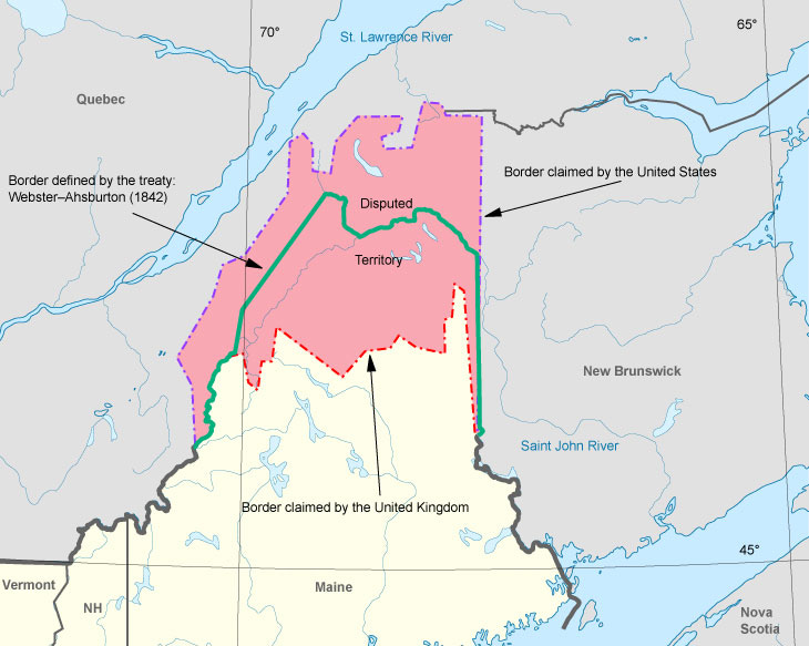
So, for decades, both American and British settlers pushed into the contested territory of northern Maine, leading to tensions between the two countries (something that happened quite often in the 1800s. The Aroostook War, a bloodless conflict in 1838-1839, highlighted the need for a definitive resolution to who owned what in the region. Officially, no shots were fired in the “conflict,” but both sides mobilized militias, demonstrating the potential for serious conflict. According to reports, the U.S. mobilized 6,000 militiamen while the British mobilized 15,000. And at the core of the dispute? The differing interpretations of the Treaty of Paris of 1783, with each side claiming vast tracts of timber-rich land.
The eventual solution came with the Webster-Ashburton Treaty of 1842. Daniel Webster, the U.S. Secretary of State at the time, and Lord Ashburton, the British envoy, engaged in a series of intense negotiations. The outcome was a compromise that established the current border. Now, if you’re eyeballing that military number above and coming to the conclusion that New Brunswick ended up with less land than it might have seemed entitled to, it's important to consider the other strategic interests and trade-offs made during these negotiations.
You see, the British were keen to use the negotiations for a few things. The first, and most immediately important to the region was to protect their communication lines, particularly the overland route between Halifax and Quebec. The negotiators drew a line that largely followed the natural watershed, but with significant adjustments. But also, the British wanted to finalize the U.S.-Canada border in a few different areas. Primarily along the 49th parellel and through the Great Lakes. Basically, Britain wanted to hash out a lot of potential flash point areas with a United States that, at the time, was highly combustible.
And so, the "shoe" of northern Maine, often referred to as the "Aroostook wedge," became part of the United States due to a combination of factors. American claims in the area were strong, based on settlement and economic activity, particularly logging. Furthermore, the British were willing to concede this territory in exchange for other gains, such as a more favorable boundary further west and the preservation of their preferred military communication routes. The treaty also clarified the border around Lake Superior and Lake of the Woods, and granted the British navigation rights on the St. John River, which was crucial for their timber trade.
In the end, New Brunswick "got squeezed out" not because of a lack of a strong claim, but because the broader geopolitical interests of the United States and Great Britain led to a compromise that prioritized other considerations. And now we have a distinct northeastern shoe-shaped state.
History is funny sometimes.
"this is a land that is farther north than any other part of the contiguous United States"
Actually, you mean the *eastern* contiguous United States, anything east of Minnesota, because the northernmost part of Maine is south of the actual 49th parallel.
Without looking at a map - is the state with no straight border South Carolina? Also a correction - a piece of MN is slightly farther north than ME (which I’m sure also has an interesting story behind it!).